All the Maps at Once
Hundreds of thousands of historical maps have been digitised by museums, libraries and organizations such as the David Rumsey Historical Map Collection. A very large number of those digitized maps can be accessed and viewed using IIIF.
IIIF is a set of open standards for sharing and viewing online high-quality digital images. It is a format which is increasingly being used to digitize and share online historical vintage maps. For example I have recently used the IIIF manifests of vintage maps created by the John Russell Bartlett Library and the David Rumsey Historical Map Collection to create interactive annotated maps of:
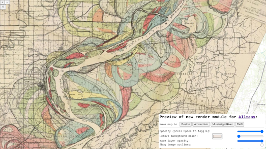
Another great example of using IIIF to explore vintage maps is the Allmaps WebGL2 Preview. This interactive map uses the IIIF manifests of lots of different historical maps to overlay a number of different vintage maps on top of a modern map.
You can use the location links on the WebGL2 Preview map to view vintage maps of Amsterdam, Boston, Delft and Harold Fisk's 1944 Meander Maps of the Mississippi River. The map also contains controls which allow you to adjust the opacity of the vintage map overlays and the underlying modern map.
The WebGL2 Preview was created using Allmaps. Allmaps is a fantastic platform which can be used to georeference vintage maps from a IIIF manifest and to display IIIF manifests as interactive maps. All you need to georeference or view a vintage map with the Allmaps Editor is the URL of a IIIF Image or Manifest. These manifest URL's are often freely shared on museum and library websites.
The Allmaps Editor and the Allmaps Viewer both include links to lots of examples of vintage maps which have been georeferenced or which can be viewed using the Allmaps platform.


Comments