Weather Whiplash Animated Map
Weather Whiplash is a little experiment in overlaying a video on top of Mapbox's globe projection.
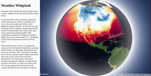
Earlier this week NASA released an impressive animation of the recent extreme weather conditions that have been experienced in North America. NASA's Weather Whiplash animation visualizes surface air temperature across North America, for December 2022 and the first few days of January 2023. The animation shows the extreme swings in temperature (from 36°F to 72°F) that many locations in the United States experienced in a very short period of time.
To create my video overlay map I cropped NASA's video and used Mapbox GL's video overlay capabilities to add the video as a layer on top of a globe projection. The Weather Whiplash map includes the option to pause and play the video by clicking on the actual video overlay.
I'm far from happy with my map. I had to crop the map in order to be able to add to the globe projection which means I lost the date label from NASA's original video. I also had to use clideo.com's cropping tool to crop the video which is why the video has an ugly watermark. I also had to georeference the video by eye (which is why it is positioned so poorly). If anyone has a link to an online rubbersheeting tool for videos (like MapKnitter for images) that would be much appreciated.


Comments