Mapping the Ocean Deep
On 21 December 1872 HMS Challenger set sail from Portsmouth on a four-year scientific expedition to map the ocean floor, to measure ocean temperatures and to document marine life. It was the first global marine research expedition. A four-year expedition which managed to discover 4,700 new species, record hundreds of sea soundings (in the process verifying the existence of the Mid-Atlantic Ridge), and make 263 water temperature observations.
The University of Illinois' Challenger Expedition portal allows you to explore an interactive map of the HMS Challenger's marine research voyage. Using the map you can follow the route taken by the ship on its four year voyage and explore some of the data recorded in the 50 volumes of the voyage's logs.
If you click on Station 1 (just west of Spain and Portugal on the map) you can start at the beginning of the ship's voyage (1872-12-30). You can then use the forward arrows to follow the voyage chronologically. The information window on the map provides details of the discoveries made at each station. It shows you the date of the observations made at this location, the recorded ocean depth, the surface and bottom temperatures, and the detected species at that location.
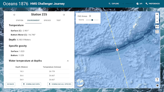
If you navigate to Station 225 on the map you can explore the results of HMS Challenger's findings at Challenger Deep (a depression now named after the Royal Naval ship). On 23 March 1875 the ship recorded a depth of 4,475 fathoms. The expedition had (unknowingly) found the deepest point on the Earth's seabed in the Mariana Trench.

Challenger Deep is deep. Very Deep. Located in the Mariana Trench, Challenger Deep is the deepest known point in the Earth's seabed. But just How Deep is Challenger Deep?
John Nelson has the answer in his beautiful Esri story map. This map helps to explain the staggering depths first discovered by HMS Challenger. As you progress through this story map you will learn about the natural forces which created this huge depression deep beneath the Pacific Ocean. You will also learn about the kind of dark inhospitable conditions which exist at so many fathoms beneath the sea.
To help convey the staggering depth of Challenger Deep the map uses a number of non-standardized units of measurement. This involves showing how many Everests, Manhattans or Grand Canyons deep the depression falls beneath the surface of the sea. To help illustrate these non-standardized units of measurement Nelson has stacked a number of Mount Everests one on top of the other and relocated the Burj Khalifa to the bottom of the Grand Canyon. All for a sense of scale - of course.


Comments