Caltech's New Map of Mars
Caltech's Bruce Murray Laboratory for Planetary Visualization has unveiled a new online interactive map of Mars. The map has been created using a 5.7 terapixel global image of Mars created from 110,000 individual images. Images which were captured by the Context Camera (CTX) aboard NASA's Mars Reconnaissance Orbiter (MRO).
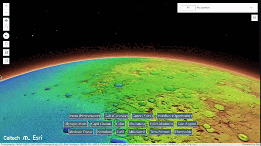
The Global CTX Mosaic of Mars interactive map contains a number of handy links to help inter-planetary explorers avoid becoming lost on the red planet. Clicking on the provided links will automatically pan and zoom the map to some of the planet's most memorable topographic features and to some of the locations on Mars which have been traversed by NASA's Curiosity and Perseverance Rovers.
Caltech's map uses Esri's SceneView interface. This enables the new imagery to be viewed on an elevation model of Mars. It is therefore possible to use the Global CTX Mosaic of Mars to explore the planet's mountains and craters in 3D. For example using the map you can pan around Olympus Mons, the tallest volcano in our solar system. Alternatively you can dive into the huge Jazero or Gale craters on this high resolution map of Mars.
According to NASA the new map is "the highest-resolution global image of the Red Planet ever created". NASA's Mars Reconnaissance Orbiter has been capturing imagery of Mars since 2006. This new mosaic of this imagery provides a resolution of around 25 square meters per pixel. The highest resolution at a global scale was previously 100 meters per pixel. The new map therefore represents a 20-fold increase in resolution from previous interactive maps of Mars.


Comments