Wildfires & Smoke Pollution
Wildfires in Quebec and Nova Scotia are causing high levels of unhealthy air conditions across much of eastern Canada and the northeastern United States. Over 400 fires were reported to be burning in Canada on Tuesday evening resulting in smoke pollution and dangerous levels of particulate matter 2.5 over large areas.
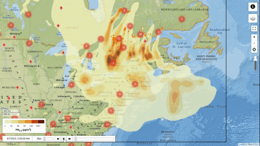
FireSmoke Canada has an interactive smoke forecast map which provides forecasts for the next few days. The current forecast shows that a large area of eastern Canada and the northeastern U.S. should expect dangerous levels of PM2 at times over the course of this week.
FireSmoke Canada forecasts are produced by the BlueSky Canada smoke modelling system, which is an ongoing research project at the University of British Columbia. The system uses satellite detections to locate fires, weather forecasts to predict how the smoke will move, and a dispersion model to calculate how smoke will be distributed in the atmosphere. The forecasts are updated every 6 hours and show the expected concentration of PM2.5, a type of particulate matter that can be harmful to human health, at ground level from wildfires.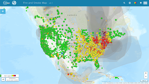
AirNow's Fire and Smoke Map shows the Air Quality Index (AQI) levels across the United States and Canada. It allows you to view the current particle pollution air quality at your location. It can also give you information about fires and smoke plumes. The map currently shows high levels of air pollution in much of the state of New York. You can view AirNow's air quality forecasts for the next two days in New York regions on their New York air quality forecast page.


Comments