Tree Maps of the World
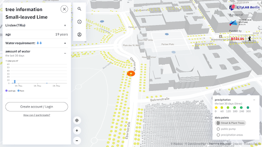
Gieß den Kiez is an interactive map of over 800,000 trees in Berlin. Using the map Berliners can discover what types of trees are growing in their neighborhood and then sign-up to help water individual trees.
By clicking on individual trees on the Gieß den Kiez (Water the Neighborhood) map you can get information about a tree's species, its age and its watering requirements. Registered users can also adopt individual trees and tag them when they have watered them. The information display for each tree includes a chart which shows when the tree was last watered.
If you want to create a Water the Neighborhood for your city then you can fork the project on the Gieß den Kiez GitHub page. Something which Leipzig Gießt has successfully managed in creating a map of over 60,000 trees in Leipzig. Like the Berlin map Leipzig Gieß can be used to find out about local trees and to sign-up to help water individual trees.
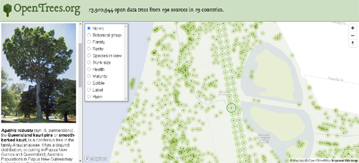
Steve Bennett has created a global database and interactive map of open tree data from around the world. His OpenTrees.org map shows the location of nearly 14 million trees in over 190 cities around the globe in 19 different countries.
Many local and municipal governments keep a record of all the trees that they are responsible for maintaining. OpenTrees.org uses this data to create a worldwide map of trees. When you select a city marker on the map you can explore an overview of the tree data kept by the city. This includes information on the number of different trees of different species and the type of data which the city records about each tree.
The map menu allows you to change how the trees appear on the map. For example you can see all the tree markers in a city colored by species, or sized by trunk size. If you select an individual tree on the map you can view its scientific and common name. You can also view images and information on the selected species of tree (this information is taken from Wikipedia). The map also includes a link to view a selected tree on Google Maps Street View (where available).
When you select an individual tree on the map you should also be able to find a link to the original data source. These local municipality databases have also been used to create the following city tree maps:
The New York City Street Tree Map
Melbourne Urban Forest
London Tree Map
Trees of Madison
Amsterdam Tree Map
Comments