The Google Maps team have today announced the "Google Maps API for Flash Utility Library" open-source project. The three initial libraries are a marker manager, a KML parser and Planetary Map Types (Google Moon, Mars and Sky).
Via: Google Geo Developers Blog: Open-Sourced Goodies for your Flash Maps: KMLParser, MarkerManager, and Planetary MapTypes
__________

Monday, September 15, 2008
Paralympics Medal Map
Supernifty

A couple of week's ago Supernifty created a Beijing 2008 Medallists Map. Now they have created a Google Map mash-up of all paralympic medallists at the Beijing 2008 paralympics.
The map will be updated daily until the end of the games. Each of the tags placed on the map includes a link to the athlete's profile on the official Beijing Olympics website.
__________
Some Google Maps Mash-ups Updates
YourStreet
YourStreet is a Google Map mash-up that informs you about what’s going on in your town and neighbourhood by geo-tagging thousands of articles, blogs, and discussions at street level.
Google Maps Mania reviewed YourStreet when it launched last year and now we are happy to bring you news of a major new redesign of the site.
Mapdango

Mapdango is a Google Maps mash-up that lets users quickly, and easily discover information about any city or town in the world. Google Maps Mania originally reviewed Mapdango back in January but has recently undergone a revamp.
Now when you search for a place on Mapdango you will receive information from Panoramio, WeatherBug, Flickr, Eventful, Google Local, YouTube, Geonames, and a whole bunch of other APIs, including FriendConnect. Content on the site is broken into three categories, based on a 'dashboard', a map, and a social view. Also included is a country/city index for major cities, and an RSS feed that shows a new randomly selected place every day.
__________
YourStreet is a Google Map mash-up that informs you about what’s going on in your town and neighbourhood by geo-tagging thousands of articles, blogs, and discussions at street level.
Google Maps Mania reviewed YourStreet when it launched last year and now we are happy to bring you news of a major new redesign of the site.
- An innovative drag and drop interface for adding content to the map lets users simply drag pins onto a map.
- User generated content is highlighted on the right side of every page. Local discussions and neighbour activity is given new prominence on the site, emphasizing user contributions.
- Users can filter news by topic. For example, you can just view New York crime news if you wish.
- Popular articles, discussions, and active neighbours are now highlighted, allowing users to find the most viewed items on the site.
- Every location now has separate news, discussion, and neighbours tabs at the top of the page to enable users to more easily find out what's going on around them.
- All content areas fit on one screen. With the new design there is a minimum of scrolling necessary. You simply click the next button to view the next screen of information.
- Page loads are minimized. Extensive ajax has been implemented throughout the site to reduce page loads and significantly speed up the user experience.
- We have introduced map-based advertising via a partnership with Lat49. As you drag the map, the ad unit below the map changes to reflect the location you are viewing. This will allow us to serve up more highly geotargeted ads to users.
- We now have local news headline widgets for every town and thousands of neighbourhoods in the country. Users can paste these into a web page or blog to have continuously updated articles displayed for their specific location.
Mapdango
Mapdango is a Google Maps mash-up that lets users quickly, and easily discover information about any city or town in the world. Google Maps Mania originally reviewed Mapdango back in January but has recently undergone a revamp.
Now when you search for a place on Mapdango you will receive information from Panoramio, WeatherBug, Flickr, Eventful, Google Local, YouTube, Geonames, and a whole bunch of other APIs, including FriendConnect. Content on the site is broken into three categories, based on a 'dashboard', a map, and a social view. Also included is a country/city index for major cities, and an RSS feed that shows a new randomly selected place every day.
__________
Google Maps Clustering Solution
Click2Map
Google Maps mash-ups can suffer performance problems when trying to display a large number of markers at any one time. In order to avoid performance issues when displaying hundreds of markers some kind of clustering needs to be implemented. Today Click2Map have released their clustering solution.
This new feature from Click2Map is demonstrated in the video below:
Click2Map is an easy to use application that lets you create, manage and publish Google Maps without any knowledge of programming. Now, with the introduction of this clustering solution, you can build maps with thousands of markers.
________________
Friday, September 12, 2008
Monetise Your Google Maps
lat49
Google Maps developers can monetise their maps using lat49's advertising system that serves geographically relevant advertising to map users. lat49 ads can be easily incorporated into any map by using a straight-forward javascript API.
The ads can be placed on the maps themselves or you can use lat49's off-map ads. These come in a number of sizes such as Leaderboard (728x90), Medium Rectangle (300x250), and Full Banner (468x60). Both the map ads and the off-map ads are geo-targeted and are directly related to the users' interaction with the map.
This week lat49 also released a new API for Flash-based maps/mashups. So if you use the Google Maps API for Flash it is now possible to integrate the full functionality of lat49 quickly and easily. As with the lat49 Ajax map API, ads can be displayed either on the map itself, or off-map.
AdSense
Google Maps developers can also use Google's own AdSense programme via Gadsmanager. Gadsmanager serves geographically relevant ads as small tags on Google Maps. Map developers earn revenue from the maps when users click on the ads.
Friday Google Maps Fun
Street View Game

This fun street view game is in the tradition of the classic text adventure games. The object is to follow the clues around Sydney, Australia to solve a mystery. Are ready to play? Agent Y is waiting for you at the Sydney Opera House with your instructions.
Travel Map Generator
The Travel Generator uses the Google Charts API to create a small map for your website or blog showing the countries you have visited.

Election '08 Twitter Chatter

Are you desperate to know what is being said on Twitter about Obama, McCain and Biden, Palin? Election '08 Twitter Chatter maps the latest Twitter comments and YouTube videos about the four election hopefuls. Just click on the grinning photo of any of the four politicians to find out what people are saying about them.
It's kind of like having your own focus group.
Planet Paint

Google Blogoscoped are quick of the mark with a fun application that makes use of the new views available in Google Static Maps. The application displays a random location (from 300 available cached random locations) with some image filters like contrast and inversion applied to make some interesting Google Map art.
Street View of the Week
I want this bear statue!
View Larger Map
Via: Street View Gallery
__________
This fun street view game is in the tradition of the classic text adventure games. The object is to follow the clues around Sydney, Australia to solve a mystery. Are ready to play? Agent Y is waiting for you at the Sydney Opera House with your instructions.
Travel Map Generator
The Travel Generator uses the Google Charts API to create a small map for your website or blog showing the countries you have visited.
Election '08 Twitter Chatter
Are you desperate to know what is being said on Twitter about Obama, McCain and Biden, Palin? Election '08 Twitter Chatter maps the latest Twitter comments and YouTube videos about the four election hopefuls. Just click on the grinning photo of any of the four politicians to find out what people are saying about them.
It's kind of like having your own focus group.
Planet Paint
Google Blogoscoped are quick of the mark with a fun application that makes use of the new views available in Google Static Maps. The application displays a random location (from 300 available cached random locations) with some image filters like contrast and inversion applied to make some interesting Google Map art.
Street View of the Week
I want this bear statue!
View Larger Map
Via: Street View Gallery
__________
Thursday, September 11, 2008
Track Hurricane Ike on Google Maps
Hurricane Ike is currently heading towards Texas, where more than a million people have been told to leave their homes.
Hurricane Ike Twitter Chatter

Twitter often seems to beat the mainstream media to the important news. Therefore Virender Ajmani has quickly put together this mash-up that shows the latest comments on Twitter about Hurricane Ike alongside a Google Map that is tracking the hurricane. The site also shows the latest videos of the hurricane uploaded to YouTube.
Other Sites Tracking Hurricane Ike
Ibiseye
StormAdvisory
Wunderground
FLHurricane.com
Firstcoastnews.com
Ibiseye and Gadget Planet both also have Google Gadgets tracking Hurricane Ike so you can add maps of the storm to your home page.
________________
Hurricane Ike Twitter Chatter
Twitter often seems to beat the mainstream media to the important news. Therefore Virender Ajmani has quickly put together this mash-up that shows the latest comments on Twitter about Hurricane Ike alongside a Google Map that is tracking the hurricane. The site also shows the latest videos of the hurricane uploaded to YouTube.
Other Sites Tracking Hurricane Ike
Ibiseye
StormAdvisory
Wunderground
FLHurricane.com
Firstcoastnews.com
Ibiseye and Gadget Planet both also have Google Gadgets tracking Hurricane Ike so you can add maps of the storm to your home page.
________________
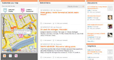
Add Google Maps to Locations on Your Site
MapMyPage
MapMyPage is an awesome new utility that enables bloggers and web site owners to attract and engage their visitors by adding maps, photos, weather, and more to the locations mentioned in their web pages. What's even better is that to do this bloggers only have to add a tiny piece of code to the html of a page. Here it is:
If you add that tiny piece of code to the code of a web page every time a location is mentioned on that page a small globe will appear next to the location. When visitors click on that globe a Google Map of the location will appear hovering above the page. In the Google Map a number of links are available that let your visitors view a Wikipedia article about the location, check the weather, view photos, read the news and find events and concerts at that location. There is even a link to view the location in Google Earth.
I told you it was awesome. If you don't believe me then check out the examples on MapMyPage.
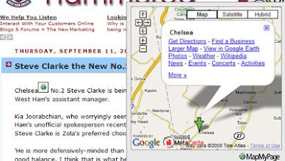
More Types of Static Maps
Until now the Google Static Maps API only let you post a static image of a 'map' view of a Google Map. Now 'satellite', 'hybrid' and terrain' views have been added to the API.
Here is a hybrid static map view of New York:

Via: Google Geo Developers Blog: You wanted other map types in the Static Maps API? You got it!
________________
Here is a hybrid static map view of New York:
Via: Google Geo Developers Blog: You wanted other map types in the Static Maps API? You got it!
________________
Trips and Places on Google Maps
TripSay

TripSay is a new travel website built around Google Maps that allows users to share their travel experiences and connect with their travelling friends to exchange insider tips. The site presents information to users based on their personal preferences and interests and the tips shown to each user consists of the things recommended by their friends and other people who share their passions.
It is possible to search the submitted places by choosing from a range of options, such as beaches, restaurants, bars, sights etc. Recommendations for your chosen option are then shown on a Google Map. Clicking on one of the tagged places opens an information window with a review of the place and the average rating given it by users.
Tripr.tv
Tripr.tv is a Google Maps mash-up of hotel video reviews. The site offers unique, individual, video reviews of hotels at the same time as showing the hotel's location on a Google Map. Each of the videos are made from a consumer's point of view.
Film-makers can upload their own hotel videos to the site and share in any commission from bookings. Here is Tripr.tv being reviewed by KTLA:
Via: Mapperz
Mapicurious
Mapicurious allows users to create their own maps of interesting points and share their created maps with others. It is possible to map points of interest by RSS, vCard and links and to explore other users' created maps. It is even possible to integrate your created map with your blog or web site or GPS.
Mapicurious were the runners up at the WHERE Developer Contest.
________________
Subscribe to:
Posts (Atom)