The Birth of Boston
A large part of Boston is built on man-made land. In the 17th Century the citizens of the Shawmut peninsula (which was less than 800 acres of land, began to use landfill and dams to make the city of Boston larger. The city has been reclaiming land from the Boston Harbor ever since.
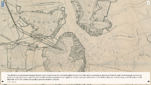
Negotiating the Shoreline is an interactive story map from the Leventhal Map & Education Center at the Boston Library which takes a look at one of the most important maps in Boston Harbor's environmental management. In 1852 the city's engineer Ellis S. Chesbrough was tasked with mapping the city's original shoreline. At the time the city was worried about Boston's main shipping channel silting up. Chesbrough's survey was designed to help the city understand how much of the Harbor had already been lost to land reclamation.
In 1852 Chesbrough estimated that Boston’s Inner Harbor had already lost 1,369 acres of water. Negotiating the Shoreline takes a detailed look at the 1852 map of Boston and Boston Harbor, exploring the city's original shoreline and the areas of the harbor already reclaimed by the mid-Nineteenth Century.

You can discover more about Boston's early development from the Birth of Boston website, which uses the Clough Land Parcel Map to explore the very earliest years of the modern city.
In September 1630 the English colonists in Trimountaine decided to
rename their settlement 'Boston', after the English town in Lincolnshire. Just eighteen years later, in 1648, much of the Shawmut
peninsula had been parceled out, claimed and settled by different colonial families. You can discover which families lived in Boston in 1648 using the Birth of Boston map created by Northeastern University.
The Birth of Boston is a collaborative project from Northeastern University and the
Massachusetts Historical Society. The map uses the historical Clough Land Parcel Map to show Boston's early land parcels and who lived in them. Samuel Chester Clough was a nineteenth-century cartographer, who tried to map the early years of Boston using the data from The Book of Possessions, a nineteenth century catalog of Boston's historic registration records. The 1648 Clough Land Parcel Map plots the land lots of Boston in 1648 and describes who owned them.
The Boston Public Library's Atlascope is another great resource for exploring the historical development of Boston. Atlascope includes nearly 100 vintage maps of Boston, dating back to 1867.
The Boston Public Library's collection of historical maps can help you explore how Boston has changed from the Civil War era right up until the modern day. The Atlascope interface includes options to compare any two vintage (or modern) maps side-by-side. You can also overlay one vintage map on top of another or view the two maps using a 'glass' lens view.

Comments