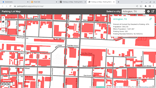
The Parking Reform Network has ranked U.S. towns based on how much land is dedicated to parking cars. Their Parking Lot Map allows you to see at a glance the percentage of the land surface area of a town or city that is taken up by parking lots and discover each city's PRN Parking Score.
PRN analyzed the amount of land taken up by parking lots in over 50 cities. It then gave each city a score based on how it compares to other cities of a similar size. A city that has a high Parking Score has a high percentage of city land devoted to parking cars. A low Parking Score means that less land is taken up by parked cars.
Arlington, Texas tops the rankings with a Parking Score of 100. 42% of the central area of Arlington is taken up by parking lots. At the other end of the scale is San Francisco, with a Parking Score of 4. Only 4% of central San Francisco is dedicated to parking automobiles.
If you don't live in the U.S., or your map isn't one of the 50 cities analyzed by PRN, you can see how much of your own neighborhood is dedicated to parking cars using this Overpass Turbo query. Just center the map on the location you wish to analyze and press the 'run' button. Overpass Turbo will then highlight in red all the parking lots at that location.
You can also use the
Parkulator map to see how much of your town is dedicated to cars. Parkulator is an interactive mapping tool which allows you to discover how much of your town is dedicated to parking lots, golf courses, brownfield sites, solar generators or parks.
If you draw an area on the Parkulator map you can choose to find out how much of that area's real-estate is claimed by parking lots. Parkulator will also tell you how much housing or how many parks could be built instead on that area of land. In addition the Parkulator map can show you how many railway stations, light-rail stops, subway stops of tram stops are in that same area.
In the United States it is also possible to explore the amount of land dedicated to parking lots on the USA Parking Lots interactive map.
USA Parking Lots is an interactive map of the United States which blacks out every single parking lot in the country.
Because this is America if you zoom in on a major city the map usually displays a lot of black polygons.
Using USA Parking Lots you can quickly see which areas of your town or city have a high concentration of parking lots. You can then observe this same area on the Parkulator map to find out how many homes you could build in this area or how much parkland you could have if your city had better public transportation and dedicated bike lanes.

Comments