The Rise & Fall of the Irish Railway
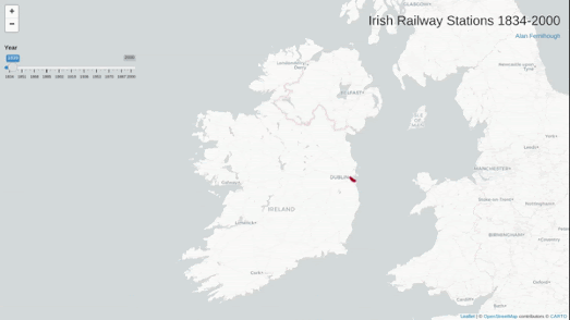
Irish Railway Stations 1834-2000 is a simple interactive map which plots all the Irish train stations which are / were open for every year from 1834 to 2000. By scrolling through all 166 years on the map you get a great overview of the rise and fall of the railway in Ireland.
The first railway line opened in Ireland was the Dublin and Kingstown Railway (D&KR), which ran between Westland Row in Dublin and Kingstown (Dún Laoghaire), a distance of 10 km (6 mi). It was opened on 17 December 1834. In 1839 a second railway line, the Ulster Railway, opened between Belfast Great Victoria Street and Lisburn.If you use the map's timeline to progress through the years from 1834 you can see how the railway spread across Ireland, largely emanating out from the initial lines built in Dublin and Belfast. For almost a century after 1834 the railway in Ireland continued to grow, reaching out to all parts of the island of Ireland.
When you reach the late 1930's on the map you can begin to see railway stations disappearing off the map. The Great Depression and the rise of the motor car obviously had an effect of freight and passenger traffic resulting in the closure of a number of stations. In the 1950s and 1960s you can begin to see the closure of many branch lines on the map. This significant reduction in the rail network in Ireland means that even in the 21st Century the Irish rail network consists of only around 1,698 miles, or around half of the 3,480 miles of line that existed in the early 20th Century.
Also See
A Journey Through the History of Swiss Railways - mapping 175 years of Swiss rail
Zeitlinie Vienna - Vienna's tram network since 1865
Zeitlinie Graz - an animated map of Graz's tram network since 1878Citylines - mapping transit systems around the world over time


Comments