Isochrone Maps by Time of Travel
An isochrone map shows the area that you can travel to from one point within a certain time. For example it can show you how far you can drive from your home in one hour. Ironically, despite being a visualization of time, most isochrone maps actually completely ignore the actual time of day when you wish to travel. For example they mostly ignore the fact that the distance you can drive during rush hour is likely to be a tiny fraction of the distance that you could drive at 2am in the morning.
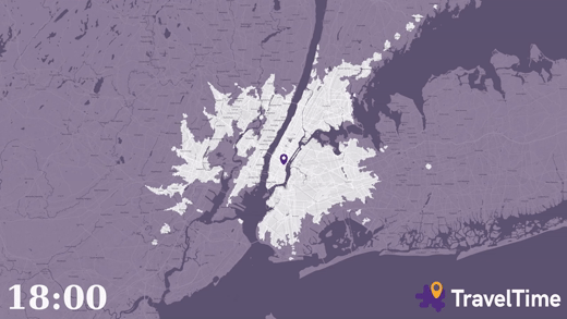
TravelTime has being working on visualizing how the time of day can affect how far you can travel within a set period of time. In Visualising How Far You Can Travel from New York’s Grand Central Station by Time of Day TravelTime has created an animated isochrone map which shows the distance you can travel by train in one hour throughout a 24 hour period. The map uses the TravelTime API to calculate travel times based on the scheduled timetable.
The animated map shown at the top of this post concentrates just on the evening rush hour period between 6pm and 7pm. You can view the YouTube video of this map here. Both of the animated maps assume that the traveler must first walk into Grand Central station and walk to the train platform, wait for a scheduled connection and have enough time to exit the station on the other side. You can check the routes shown on the map yourself using the TravelTime interactive travel time map.
You can view many more travel time maps by checking out the isochrone label on Maps Mania.


Comments