The Black Elevation Map

The Black Elevation Map is a comprehensive guide to the black cultural sites, black historical landmarks and black owned businesses which can be found in America's towns and cities. This new interactive map uses data from a number of sources to show the concentration and locations of black owned businesses and black historical markers across the country.
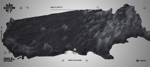
The initial Black Elevation Map view of the United States uses elevation as a means to represent the density of either black owned businesses, black population density or black historical markers in the USA. For example the screenshot above shows the density of black historical markers (with the greatest density appearing to be in the north-east). The screenshot below shows the density of the black population. This map uses data from the Decennial 2020 U.S. Census.
Comparing the two maps it is very apparent that while southern states have a high black population density they also don't appear to have a particularly high density of black historical markers. It is almost as if black history isn't valued very highly in most southern states.
If you open the map menu and select 'Tour the Culture' you can select to view one of eleven guided tours of the black cultural data shown on the map. These include tours of restaurants that fueled the civil rights movement, the work of black architects, and venues that helped shape American music. The Black Elevation Map also has 12 city guides, which provide suggestions on things you can see, place you can eat, and things that you can do in cities such as New York, Chicago, LA, and beyond.
You can also use the The Black Elevation Map to explore the black businesses, history and culture of your own town. Enter the name of a US location into the map and you can view local black owned businesses and local black cultural & historical places of interest. You can even save your favorites or share locations via social media or e-mail.


Comments