Climb Mount Everest in 3D
Mount Everest 3D is an impressive 3D map of the world's tallest mountain and the peaks which surround it in the Himalyayas. The map uses high resolution aerial imagery draped over a 3D digital elevation model to provide a unique view of one of the world's most beautiful and inspiring landscapes.
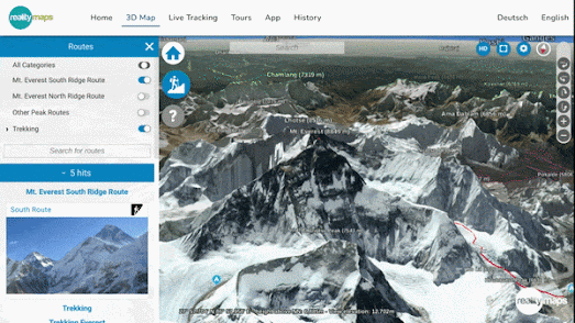
As wall as being able to pan around and zoom in on the wonders of the Mahalangur Himal sub-range of the Himalayas the Mount Everest 3D map includes overlays showing the two most-travelled routes to the peak of Everest. These route overlays include waypoints showing the locations of camps along the route, and photographs of the Himalayan scenery.

You can get an even closer view of the Everest region of the Himalayas with Google Maps Street View.
To capture 360 degree panoramic imagery in the Himalayas Google teamed up with Apa Sherpa (a Sherpa mountaineer who holds the world record for reaching the summit of Mount Everest 21 times) and the Nepalese nonprofit organization Story Cycle. During a 10-day trek through the Khumbu region with Apa Sherpa Google managed to capture Street Views of mountain trails and a number of Sherpa villages. The best way to explore this Street View imagery is to visit the Khumba map on Google Treks.
The Khumba site on Google Treks includes some lovely hand-drawn maps of the featured villages. Each of the maps include map markers which lead to Street Views captured on Google's 10-day trek. These include Street View imagery of monasteries, temples, trekker's lodges and of course some wonderful mountainous scenery.

Comments