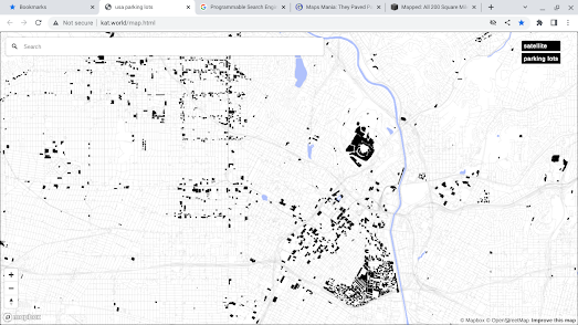
USA Parking Lots is an interactive map of the United States which blacks out every single parking lot in the country. Of course because this is America it means that if you zoom in on a major city the map displays a lot of black polygons.
Because the map doesn't have a FAQ page I don't know how the data for the parking lots was obtained. If I was going to make a similar map for the UK I would probably use Overpass Turbo to retrieve the data from OpenStreetMap.
America is very much still in love with the automobile and as a European it is always shocking to see how much urban space in the United States is devoted to the car. This is perfectly illustrated by Better Institutions. Back in 2016 Better Institutions created an interactive map to visualize the 200 square miles of Los Angeles parking lots as one huge circle.

Los Angeles has around 200 square miles of parking spaces. This means that there is more space for each car in Los Angeles county than there is for each person. To help illustrate the amount of space given over to parking cars in LA Better Institutions lumped all these parking lots together to create one big imaginary parking space.
This parking space is 16 miles in diameter.
Unfortunately the USA Parking Lots map doesn't include any measurements detailing the amount of space dedicated to car parking spaces in individual American cities. If I had one feature request for this map it would be to show the total area of space in the current map view which is dedicated to car parking (possibly using
turf.js to calculate the area inside all the parking lot polygons in the current map view)
This
Percent Built On map from Ordnance Survey has the kind of functionality I'm after. This OS map allows you to define an area by drawing on the map and then calculates the percentage of the selected area covered by buildings. It would be great to have the same functionality on the USA Parking Lots map in order to show the percentage of the defined area that is covered by parking lots.


Comments