Detecting Wildfires from Space

Le Parsien has been using imagery from the European Space Agency's Sentinel satellite array to show the spread of two wildfires currently raging in the Gironde region in southwest France. In Fires in Gironde: the fight is also being fought from space the newspaper shows how satellite imagery has been used to detect the locations of active fires, the wind direction, the extent of fire damage and the location of infrastructure which is in imminent danger from the spread of active fires.
Earlier this month two fires began in Gironde. The Sécurité Civile quickly requested that ESA's Copernicus program monitor the fires. Over more than a week the fire currently active in La Teste (shown above) has burned over 7,000 acres. Satellite imagery from ESA shows the extent of this burning. Analysis of the satellite imagery can also identify the location of residential buildings and of other important infrastructure which is in danger from the spread of the fire. It can even be used to identify the topology of vegetation in the affected areas, to help model how the fires might continue to spread.
Le Parisien uses a series of satellite imagery of the La Teste wildfire and the Landiras fire to illustrate how emergency services are using space technology to fight and help manage the two main wildfires currently raging in Gironde. In Feeling the Heat from Space the European Space Agency itself uses satellite imagery to show how the Copernicus Emergency Management Service is being used to respond to wildfires across Europe.
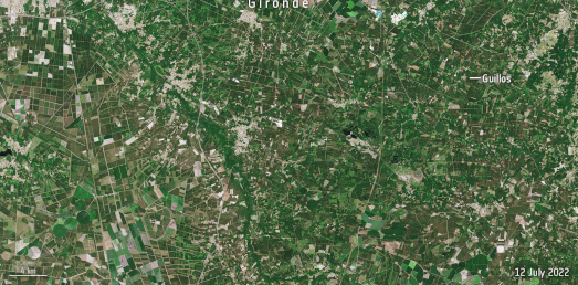
The ESA article includes the animated GIF above showing the active fires and burnscars from the wildfires near the commune of Guillos in Gironde. The ESA article also includes satellite imagery of the active fires in La Teste.


Comments