The (Not So) Great Salt Lake
The Great Salt Lake in Utah is very, very big. Although it isn't as big as it used to be. In 1987 the lake was 3,300 square miles in size. Now, in July 2022, the lake is only around 950 square miles in size. While the size of the Great Salt Lake can fluctuate a lot naturally, due to seasonal changes in the weather, it is now undoubrably drying-up because of global warming.
You can see how drastically the Great Salt Lake is shrinking in size by viewing the lake from Space. Google Earth Timelapse allows you to view historical satellite imagery for any location on Earth. The application has 37 years worth of satellite imagery dating back to the 1980s. It is therefore possible to use Google Earth Timelapse to create your own animated timelapse image for any location showing changes over time.

If you center on the Great Salt Lake in Utah on Google Earth Timelapse you can clearly see the extent that the lake has shrunk since the 1980s simply by pressing 'play' on the map's timeline.
Using Google Earth Timelapse to visualize the drying-up of the Great Salt Lake is very easy. What isn't so easy is documenting the toll of climate change on the lake by kayaking around its full circumference. Which is what EarthView did to create a 'Street View' type tour of the lake. Their Tour of the Great Salt Lake allows you to explore a first-person view of the lake in glorious 360 degree panoramic imagery.
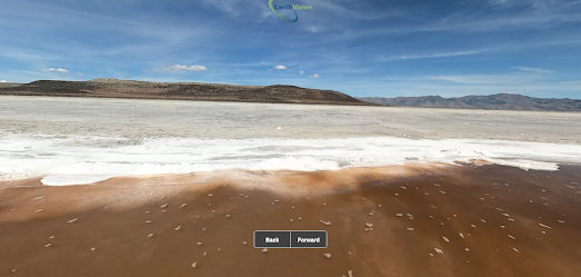
In June EarthView captured panoramic imagery by kayaking around the lake's eastern shore. They plan to capture imagery of the western shore in the fall. There are also plans to capture similar 'Street View' type imagery for Lake Powell, Lake Mead, Lake Tahoe and New Mexico’s Rio Grande.


Comments