The Loss of the Great American Grasslands
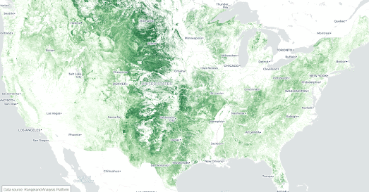
The Cornell Lab of Ornithology and the Act for Grasslands. have teamed up to map the loss of grasslands in the United States. Over 2 million acres of American grasslands are lost on average every year. The result of which has a devastating effect on American wildlife.
Using historical satellite records Map for Grasslands has tracked grassland loss in the USA over the last 30 years. By mapping and comparing grassland coverage across the United States in 1992 and 2021 Map for Grasslands is able to visualize the incredible extent of grassland loss in just the last three decades. Map for Grasslands has also created a small multiple visualization zooming in on the grassland loss in different regions of the United States. This visualization allows you to compare 1992 and 2021 grassland coverage in the Southeast, Midwest, West, and Northeast in more detail.
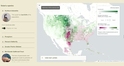
To help explain the effect that the loss of grassland habitats has on wildlife Map for Grassland has also used an interactive map to plot the loss of animal species ranges on top of this grassland loss. This map allows you to compare the loss of range of a number of different animals and birds. For example the screenshot above is a map visualizing the loss of range of the Northern Bobwhite quail superimposed on a layer showing grassland loss. You can see that the loss of grasslands in the Great Plains has had a devastating effect on the numbers of quail surviving in this region.
Via: Quantum of Sollazzo


Comments