The Best Google Maps of 2008 - Part Two
July Through to December
This is the second part of my round-up of my favourite Google Maps mash-ups produced this year. I'm sure many of you will have disagreed with my choices. If you have your own favourites you can always leave a comment!
July
UMapper
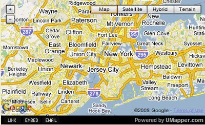
Umapper is a great new creation tool that excels in the number of user options it offers. It includes geocoding, and Wikipedia and image options.
TVTrip
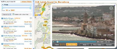
TVtrip is a very impressive search engine for hotels that uses Google Maps to show the locations of hotels. The site currently maps 33,281 hotels worldwide and includes 7,652 hotel videos.
tripwolf
tripwolf is a social travel guide that combines editorial travel content with user generated content. Using tripwolf travellers can create customized travel guides of their favourite destinations.
August
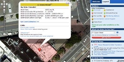
Roofray
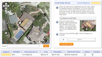
Have you ever thought about adding solar panels to your house? Roofray can help you decide. Roofray is an amazing tool built on Google Maps that can calculate the solar energy potential of your house.
To do this you start by simply tracing a a polygon on top of the Google Map satellite image of your house. When you have traced your roof you then drag a marker on the map to show the direction your roof slopes. The next step is simply to enter the angle of your roof tilt.
Where is the Path
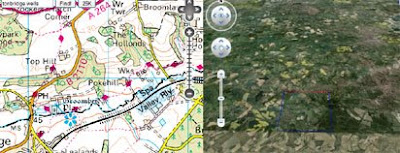
Despite the introduction of walking directions to Google Maps sometimes you still need to look elsewhere. In the UK Google Maps are still not mapping public footpaths. That is why I frequently use Where is the Path, which displays Google Maps alongside the corresponding Ordnance Survey Maps.
Dipity


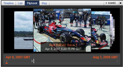
Dipity allows users to easily create timelines on any subject. The created timelines can then be embedded in a website or blog. That in itself would be a reason for great cheer but Dipity also allows users to geo-tag the events on a Google Map. It is therefore possible to show the progress of a subject both chronologically and geographically.
September
Earth@Sg Singapore Grand Prix Track
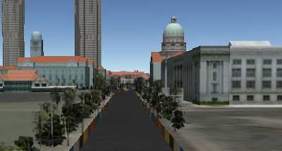
In September Earth@Sg produced this amazing Google Earth browser tour of the Singapore Grand Prix race track. Earth@SG created 3D models not only of the race track and the surrounding buildings but included superb details such as 3D trees.
The Kremer Collection

The Foundation Aetas Aurea's collection of 17th century Dutch and Flemish Old Masters is now viewable via the Google Maps interface. Twenty five paintings from the collection have been made into custom tiles and are used instead of the map tiles in 25 separate Google Maps mash-ups.
MapMyPage
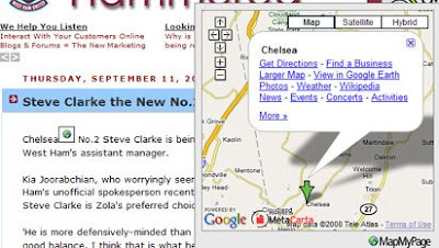
MapMyPage is an awesome new utility that enables bloggers and web site owners to attract and engage their visitors by adding maps, photos, weather, and more to the locations mentioned in their web pages. Add some code from MapMyPage and all the locations on a page will have a pop-up map added.
October
The Fitsrovia Apartments
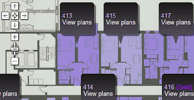
The Fitzrovia Apartments is a great Google Maps mash-up designed to promote apartments in central London. The site uses Google Maps not only to show the location of the apartments but also to display plans of individual apartments, floor plans of the whole building and a map showing local points of interest and facilities.
Earth Atlas
Thematic Mapping's Earth Atlas is a prototype web application for viewing KML files with the Google Earth Browser plugin. Earth Atlas comes with links to many of Thematic Mapping's own KMLs. It is also possible to view any KML file in Earth Atlas by pasting the address into the 'Your KML' panel in the left hand sidebar or by adding the KML to the Earth Atlas URL.
TrekinU
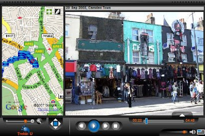
TrekinU is a great Flash based application for presenting your favourite photographs. The application shows where the pictures were taken on a Google Map and also lets you add your own soundtrack to the presentation.
November
V-Trafic
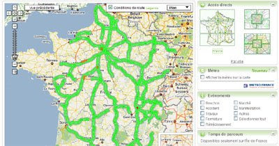
V-Trafic is an amazing Google Maps mash-up showing current traffic conditions for the whole of France. The map is amazing both for the breadth of its coverage and for the sheer number of sources it uses.
The AA Route Planner
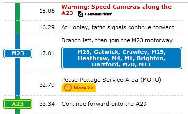
This route planner from the Automobile Association in the UK actually improves on Google's own driving directions. It is in the detailed breakdown that the AA excels. The site mirrors the colour coding of UK road signs. It also includes traffic camera warnings, informs you when you will be passing a gas station, a hotel and or even an IKEA (just in case you need some Swedish flat-pack for your journey).
Young People's Stories
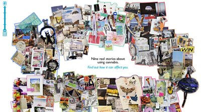
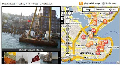
Australia's National Cannabis and Information Centre put together this rather beautiful collage using the Google Map's API. The collage contains nine real stories by young people telling their experience of using cannabis.
iMap Weather
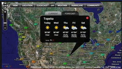
iMap Weather map uses the Flash Google Maps API to provide a weather map with an incredible number of features. It is possible to view the weather and weather forecast for any location in the world. In the US you can view a nationwide radar image that is zoomable to street level! It is even possible to view a hurricane forecast and to view buoy and ship data. You can also embed the map in your own website or blog.
Barack Obama's Journey to the Whitehouse
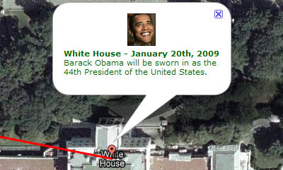
In November there was a small election in the US. This was one of the many great maps produced for the election. The map plots the life journey of the next President of the United States. Starting in Honolulu, Hawaii on August 4, 1961 this map plots Obama's life on Google Maps, from his birth all the way to his future new home in the White House in January.
December
TimeSpace: World
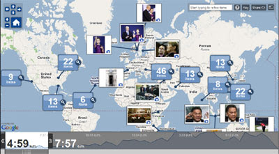
The Washington Post's new Flash based Google Map compiles all the world news content from The Washington Post, washingtonpost.com, PostGlobal, Foreign Policy magazine, and partner sites including The Associated Press and Reuters onto one customizable map. All the news coverage is collected into clusters around hot-spots on the map. By clicking a cluster, users can view articles, blog posts, photos, videos, and even reporters' twitter feeds.
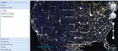
San Francisco Solar Map
Engineering company CH2M Hill has teamed up with the U.S. Department of Energy to provide solar maps of 25 American cities, using Google Maps to show the precise solar potential of individual homes. The company have just finished mapping the first city, San Francisco.
Read The Best Google Maps of 2008 - Part One (Jan -June)
This is the second part of my round-up of my favourite Google Maps mash-ups produced this year. I'm sure many of you will have disagreed with my choices. If you have your own favourites you can always leave a comment!
- The Best Google Maps of 2008 - Part One (Jan -June)
- The Year in Google Maps
- The Year 2008 on Google Earth The Google Earth Blog's summary of the updates and new features added to Google Earth this year.
July
UMapper
Umapper is a great new creation tool that excels in the number of user options it offers. It includes geocoding, and Wikipedia and image options.
TVTrip
TVtrip is a very impressive search engine for hotels that uses Google Maps to show the locations of hotels. The site currently maps 33,281 hotels worldwide and includes 7,652 hotel videos.
tripwolf
tripwolf is a social travel guide that combines editorial travel content with user generated content. Using tripwolf travellers can create customized travel guides of their favourite destinations.
August
Roofray
Have you ever thought about adding solar panels to your house? Roofray can help you decide. Roofray is an amazing tool built on Google Maps that can calculate the solar energy potential of your house.
To do this you start by simply tracing a a polygon on top of the Google Map satellite image of your house. When you have traced your roof you then drag a marker on the map to show the direction your roof slopes. The next step is simply to enter the angle of your roof tilt.
Where is the Path

Despite the introduction of walking directions to Google Maps sometimes you still need to look elsewhere. In the UK Google Maps are still not mapping public footpaths. That is why I frequently use Where is the Path, which displays Google Maps alongside the corresponding Ordnance Survey Maps.
Dipity
Dipity allows users to easily create timelines on any subject. The created timelines can then be embedded in a website or blog. That in itself would be a reason for great cheer but Dipity also allows users to geo-tag the events on a Google Map. It is therefore possible to show the progress of a subject both chronologically and geographically.
September
Earth@Sg Singapore Grand Prix Track
In September Earth@Sg produced this amazing Google Earth browser tour of the Singapore Grand Prix race track. Earth@SG created 3D models not only of the race track and the surrounding buildings but included superb details such as 3D trees.
The Kremer Collection
The Foundation Aetas Aurea's collection of 17th century Dutch and Flemish Old Masters is now viewable via the Google Maps interface. Twenty five paintings from the collection have been made into custom tiles and are used instead of the map tiles in 25 separate Google Maps mash-ups.
MapMyPage
MapMyPage is an awesome new utility that enables bloggers and web site owners to attract and engage their visitors by adding maps, photos, weather, and more to the locations mentioned in their web pages. Add some code from MapMyPage and all the locations on a page will have a pop-up map added.
October
The Fitsrovia Apartments
The Fitzrovia Apartments is a great Google Maps mash-up designed to promote apartments in central London. The site uses Google Maps not only to show the location of the apartments but also to display plans of individual apartments, floor plans of the whole building and a map showing local points of interest and facilities.
Earth Atlas
Thematic Mapping's Earth Atlas is a prototype web application for viewing KML files with the Google Earth Browser plugin. Earth Atlas comes with links to many of Thematic Mapping's own KMLs. It is also possible to view any KML file in Earth Atlas by pasting the address into the 'Your KML' panel in the left hand sidebar or by adding the KML to the Earth Atlas URL.
TrekinU
TrekinU is a great Flash based application for presenting your favourite photographs. The application shows where the pictures were taken on a Google Map and also lets you add your own soundtrack to the presentation.
November
V-Trafic
V-Trafic is an amazing Google Maps mash-up showing current traffic conditions for the whole of France. The map is amazing both for the breadth of its coverage and for the sheer number of sources it uses.
The AA Route Planner
This route planner from the Automobile Association in the UK actually improves on Google's own driving directions. It is in the detailed breakdown that the AA excels. The site mirrors the colour coding of UK road signs. It also includes traffic camera warnings, informs you when you will be passing a gas station, a hotel and or even an IKEA (just in case you need some Swedish flat-pack for your journey).
Young People's Stories
Australia's National Cannabis and Information Centre put together this rather beautiful collage using the Google Map's API. The collage contains nine real stories by young people telling their experience of using cannabis.
iMap Weather
iMap Weather map uses the Flash Google Maps API to provide a weather map with an incredible number of features. It is possible to view the weather and weather forecast for any location in the world. In the US you can view a nationwide radar image that is zoomable to street level! It is even possible to view a hurricane forecast and to view buoy and ship data. You can also embed the map in your own website or blog.
Barack Obama's Journey to the Whitehouse
In November there was a small election in the US. This was one of the many great maps produced for the election. The map plots the life journey of the next President of the United States. Starting in Honolulu, Hawaii on August 4, 1961 this map plots Obama's life on Google Maps, from his birth all the way to his future new home in the White House in January.
December
TimeSpace: World
The Washington Post's new Flash based Google Map compiles all the world news content from The Washington Post, washingtonpost.com, PostGlobal, Foreign Policy magazine, and partner sites including The Associated Press and Reuters onto one customizable map. All the news coverage is collected into clusters around hot-spots on the map. By clicking a cluster, users can view articles, blog posts, photos, videos, and even reporters' twitter feeds.
San Francisco Solar Map
Engineering company CH2M Hill has teamed up with the U.S. Department of Energy to provide solar maps of 25 American cities, using Google Maps to show the precise solar potential of individual homes. The company have just finished mapping the first city, San Francisco.
Read The Best Google Maps of 2008 - Part One (Jan -June)


Comments
Chip Hanna
http://imapweather.com/
http://www.lifesnapz.com
Geoffrey from www.tvtrip.com