Unemployment in 3D
Ubilabs has published a nice tutorial on how you can use Mapbox GL's fill-extrusion property to create a 3d mapped visualization of geographical based data. Using the fill-extrusion property you can extrude the height of shapefiles on a Mapbox GL map depending on the height of a value in your data. In this case Ubilabs have used this property to create a 3d map of Unemployment in Europe.
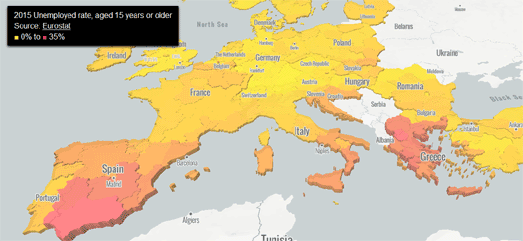
The Ubilabs tutorial shows you how you can use 'fill-extrusion-height' to apply a height to a polygon area based on data values. In the demo map European country shapefiles are extruded based on the unemployment rate in each country in 2015. Each of the country shapefiles on the map are also colored based on the country's unemployment rate.
Another good example of a map using the fill-extrusion property is this San Francisco Lidar Map, which applies the extrude property to San Francisco tree and building Lidar data. This Lidar data has been added to the map in Mapbox Studio from a GeoJSON file (presumably downloaded from the City of San Francisco). The result of using this Lidar data is that as well as visualizing buildings in 3d the map also extrudes other features, such as ships and individual trees.


Comments