Printing 3D Models of Maps
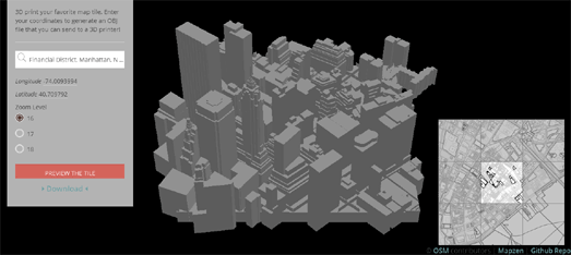
The Tile Exporter helps you to make 3d models of your favorite locations around the world. Enter a location into the Tile Exporter and it will generate the OBJ file that will allow you to print out a model of the location on a 3d printer.
Tile Exporter uses OpenStreetMap data to generate the 3d models. This means that the accuracy of the model will depend on the accuracy of the map and building height data of OSM. Luckily this is pretty accurate for most locations around the world. The Mapzen powered generation tool also means that you can preview the model on your computer screen before attempting to print it out on a 3d printer.
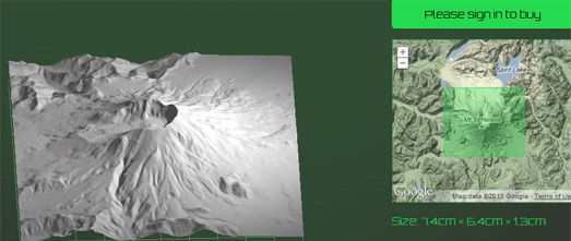
Have you ever dreamed of owning your own 3d scale model of the Grand Canyon or the Matterhorn? Thanks to the Terrainator you now can. The Terrainator is very similar in design to Tile Exporter. The main difference is that the Terrainator is used to create 3d models of interesting terrain rather than 3d buildings.
The Terrainator uses Google Maps to help you select your favorite area of terrain. It then creates an accurate scale model and uploads it to Shapeways, ready for 3d printing. The cost of the model depends on the volume of material required to make the model. Flatter models are therefore cheaper than mountainous areas, although they are much less fun. It is also possible to purchase the created STL files from Terrainator if you want to print out your own terrain model yourself.
The Terrainator is limited to areas of the world where it has accurate terrain data.


Comments