Make 3D Models in Seconds
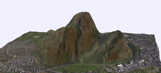
The DEM Net Elevation API can help you create your very own 3D terrain models for any location on Earth. Dem Net has a fantastic tool which allows you to create your own 3D models simply by selecting an area on a map. It really is that easy.
To create a 3D model all you have to do is draw a square on an interactive map around the area that you wish to model. Within seconds DEM Net will create a 3D model of the area that you selected. You can then rotate and zoom in & out on your model directly in the browser. You can also download the model in two different formats.
DEM-Net includes a number of options. These include a choice of different satellite imagery sources or map tile sources for your model. You can adjust the height or your model - to exaggerate the elevation levels. You can also choose to generate your model from a range of different elevation models.


Comments