Global Sunlight Chart
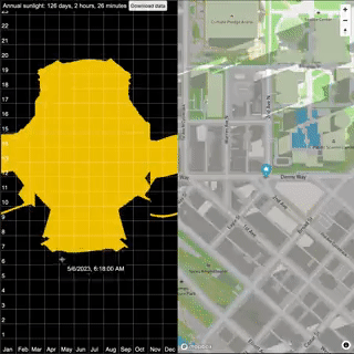
The ShadeMap: Direct Sunlight Chart is an interactive map which can calculate the number of hours of direct sunlight for any location on Earth. Unlike traditional sun charts, this map actually accounts for shadows cast by buildings and terrain. If a tall building or mountain blocks out the sun for part of the day this is taken into account in the sunlight chart for that location.
The Shademap: Direct Sunlight Chart is a great way to visualize how the latitude of a location affects the number of hours of sunlight it receives. Locations close to the equator have little variation in the daily number of hours of sunlight. The farther a location is from the equator then the larger the seasonal variation in the daily hours of sunlight.
In the image above you can see that the number of daily hours of sunshine in Ecuador, near the equator (shown on the left), remains fairly constant throughout the year. However Reykjavik, Iceland (shown on the right) has hardly any hours of sunlight in the winter months. Conversely on and near the summer solstice Reykjavik has almost 20 hours of daylight every day.
Of course the number of hours of sunlight you receive can also be affected by tall buildings and your local terrain. If you live in a valley or near a tall building then the sun may be obscured for part of the day. The animated GIF at the top of this post shows how near-by locations in the same city can have a huge difference in the number of daily hours of sunlight received, due to the presence of tall buildings. If you are thinking of moving home then you might want to bookmark this map in order to check how the local terrain or nearby tall buildings may affect the hours of sunlight received by any potential new home.


Comments
I wonder where the map gets its data from. I did a lot of research for our solar power system on the house we moved in to last year. The research was needed beause we have taller buildings to the east and to the south, and I was very lucky to find some open data from fly-over laser meterings. I used these meterings to 3D-build the neighourhood in a professional pv software and got a good shading analysis from there.
The shademapp seems to use some approximation for the mean height of buildings with gabled / hip / etc. roofs and doesn't take into account that the ridge may cast shadows onto the other side of the roof as well. For our roof, this and/or inexact height data leads to a significant underestimation of the actual shading. But all in all, I'm still impressed. This gives a rough estimate within seconds, whereas the exact simulation for our roof took dozens of hours of work on my side (almost needless to say: all the estimates from solar technicians were way off as well).