Exploring the Lakes of Mars
Freie Universität Berlin's Jezero Crater interactive map allows you to take a virtual tour of the landing site on Mars of the 2020 Perseverance rover. This tour includes a synthesized 360 degree panorama of the crater as it might have once looked, when water still existed on Mars.
The interactive Jazero Crater map shows the track of Perseverance, revealing the parts of the Jezero crater which have already been explored by the Mars rover. The map also includes a number of synthetic and real interactive 'Street View' panoramas. The real 360 degree panoramas use imagery captured by the Mars rover to show the view from inside the Jezero crater. The synthetic panoramas have been rendered from orbital image data of Mars.
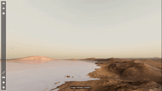
The synthetic panoramas include one, labeled Paleo Lake View, which shows the crater filled with water. This recreation of how the crater might have looked when water still existed on Mars is based on 'putative paleolake-shorelines and the upper delta-top boundary'. The Paleo Lake View panorama and all the other panoramas include Martian soundtrack. This soundtrack was created using data from the air pressure sensor on NASA's InSight lander, to give an impression of the sound of wind blowing through the Jezero crater.

The date control at the top of the Mars 2020 Mission map allows you to view the movements of the Perseverance Rover and the Ingenuity drone over the course of the mission's duration. If you select a date on this control the markers on the 3D map of Mars will show where Perseverance and Ingenuity were located on that day. When you select a day from the date control the image gallery also updates to display the images captured by the drone and rover on the selected day.


Comments