Mapping Russian Military Facilities in Crimea
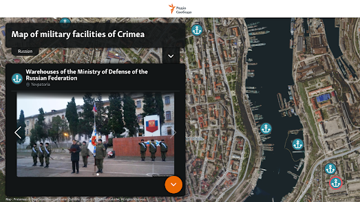
Ukrainian journalists working for Radio Liberty have released an interactive map which shows the locations of more than 200 military facilities located in Crimea. The map shows over 200 Russian military locations in Crimea categorized into 10 different categories, documented using Planet Labs satellite imagery and terrestrial photography.
Ukraine is soon expected to launch a counteroffensive against Russian troops in Ukraine. Crimea itself is probably not a realistic objective in Ukraine's forthcoming counterstrike. However as Russia is using Crimea as a staging area for its operations in southern Ukraine all Russian military locations in Crimea are likely to be attractive targets for long-range Ukrainian missiles.The new Map of Military Facilities of Crimea reveals the locations of Russian military test sites, fuel depots, ammunition warehouses, radar and air defense systems, airfields, unit headquarters, and the bases of the Russian Black Sea Fleet. You can select to view any of these categories of Russian military sites on the interactive map. If you then click on a map marker you can read a short synopsis of the site and view any available satellite imagery and / or photographs of the location.


Comments