Create Your Own Aerial Imagery Map
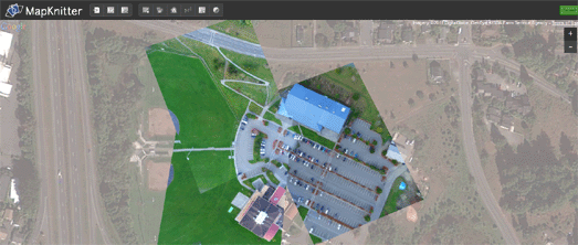

MapKnitter is a free and open source tool for aligning and creating maps from overhead images.

The tool allows anyone to take a single aerial image or a series of aerial images and align them, with the help of Google Maps satellite view. Images maps created with MapKnitter can be exported in GeoTiff, TMS/OpenLayers, and JPG formats.

You can explore maps created with the tool by location and the most recent maps are also featured on the home page of MapKnitter.

Comments

Aeroyantra said…
Unlock the potential of your projects with Aeroyantra's expert aerial mapping services! Our cutting-edge technology captures stunningly detailed aerial imagery and comprehensive spatial data, enabling you to make informed decisions faster than ever before. Whether you're involved in urban planning, agriculture, or construction, our aerial mapping solutions provide precise insights that can enhance your project's success. With our team of skilled professionals and innovative methods, we turn aerial data into actionable intelligence. Experience the difference with Aeroyantra—where clarity meets creativity. Visit us to learn more about how we can elevate your vision!

Popular Posts