Merlo's Map of Reformation Venice
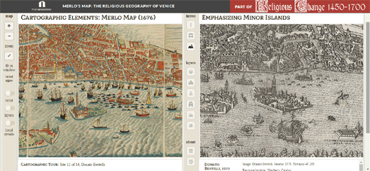
The Newberry library in Chicago has a major exhibition on Religious Change and Print, 1450-1700 opening on September 14th. In support of this exhibition they have put together an online collection of the Newberry's manuscripts, maps and images from the Reformation. This includes a superb interactive presentation of Giovanni Merlo’s engraved map of Venice from 1676.
The Newberry's interactive version of Merlo's Map includes information about the engraving and some of the Venetian locations depicted in the map. The colored circles on the map pick out some of Reformation Venice's most important churches, monasteries and printing centers. You can click on these circles to learn more about each highlighted location and view other illustrations of the location from the Newberry collection.
If you select the 'toggle maps' button (from the navigation buttons running down the center of the interactive) you can directly compare Merlo's Map side-by-side with other vintage maps of Venice. These other maps include Jacopo de Barbari 1500 map of Venice, Benedetto Bordon's map of 1534 and Paolo Forlani's Venetia from 1566.
If you like historical vintage maps then you might also like these interactive maps:
The Mappa Mundi (the largest surviving medieval map of the world)
The Gough or Bodleian Map of Great Britain (the oldest surviving route map of Great Britain)
The Oxford Outremer Map (a thirteenth-century map of Israel and Palestine)


Comments