All the Maps at Once
The David Rumsey Historical Map Collection is one of the largest online collections of digitized vintage and historical maps. The collection includes over 100,000 digitized maps. Most of which you can explore as fully geo-referenced interactive maps.
This week, in a blog post entitled More Than Digital Copies: Maps That Interpret Maps, the David Rumsey Historical Map Collection is highlighting some of the amazing composite maps that it has created over the years. The David Rumsey Collection includes many atlases and map sheet collections in which large geographical areas have been mapped and then printed over many separate map pages. By geo-referencing all the separate map sheets in a collection and then overlaying them on an interactive map the David Rumsey Historical Map Collection is able to create one complete composite map from all the maps in a single collection.
Among my personal favorite composite maps highlighted in this week's blog post is an amazing interactive 3D globe of the moon. This interactive globe was created by making a composite map from 44 separate United States Air Force and NASA maps of the moon created in the 1960s from telescope observations and photographs of the moon.
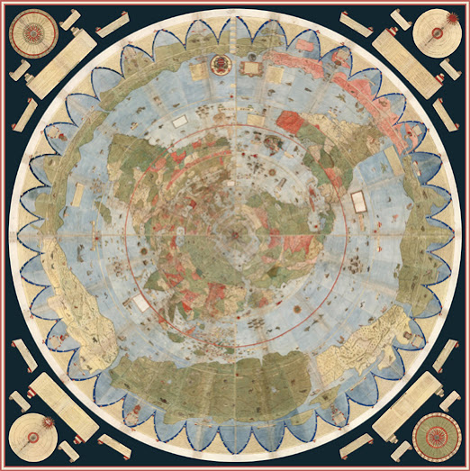
The David Runsey blog post also links to a composite map of Urbano Monte's Planisphere. The David Rumsey Map Collection obtained one of only two manuscript copies of Urbano Monte's Planisphere in 2017. Monte's huge map is one of the earliest large complete maps of the world.
The original manuscript map is in the form of a 60 sheet atlas. Urbano Monte intended for the sheets to be joined together to create one very large 10 foot map. The David Rumsey Map Collection has achieved this goal by digitizing all 60 sheets and creating a digital interactive map of Urbano Monte's Planisphere. Monte himself suggested that a central pivot be added to the center of the map so that users could rotate the map while exploring the atlas. The digital interactive version of the map does include a rotation button, which means you can now spin the map around its central pivot, just as Urbano Monte intended.
The David Rumsey Historical Map Collection composite maps blog post also includes links to a composite map of Baron Haussmann's 1868 maps of Paris (showing how he planned to transform the French capital), a 360 degree view of Santiago, Chile (drawn in 1823) and a number of other amazing composite maps.


Comments