Lighting Up the World
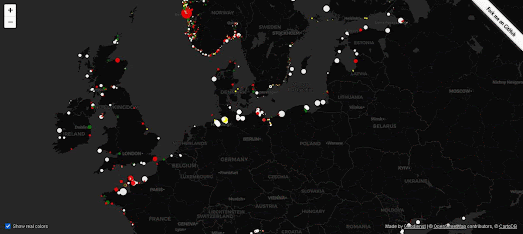
Lights at Sea is a flashy interactive map which uses OpenStreetMap data to show the locations of lighthouses around the world. The map not only shows the locations of individual lighthouses but also shows the unique flash patterns and light colors which lighthouses use so that mariners can identify them and tell them apart from other lighthouses.
Most lighthouses have a unique 'daymark'. Each one is painted with a unique pattern which enable mariners to identify individual lighthouses during the day. These daymarks often consist of large colored painted stripes, diamonds or other patterns.At night these daymarks can't be seen, therefore lighthouses have unique light characteristics which enable ships to distinguish between different lighthouses in the same coastal areas.
The Lights at Sea interactive map doesn't just show the location of individual lighthouses. Each lighthouse is also shown on the map using the real light color and flash pattern used by that lighthouse. The size of the lighthouse markers are even scaled to show the distance that each light is visible.The range of light emitted by a lighthouse is measured by how many nautical miles away it can be seen. In OSM the range of a lighthouse can be assigned using the tag 'seamark:light:range'. Lights at Sea uses this 'seamark:light:range' data to determine the size of each lighthouse's marker.

You could use just the lighthouse data from Lights at Sea to create a rough coastline map of Europe. However there appear to be less lighthouses or less lighthouses mapped in the rest of the world. It could be interesting to compare lighthouse density with global shipping traffic.
You can see on Lights at Sea that not all coastlines have lighthouses marked on OpenStreetMap. Many of these coastlines do have very busy shipping traffic. You can view most of the busiest shipping lanes around the world on
Shipmap.org. Shipmap.org is an outstanding animated map that visualizes the movements of the global merchant shipping fleet over the course of one year.
If you compare the two maps it appears that Africa and the western
coastline of South America are two areas with heavy marine traffic but
less lighthouses. I'm not sure if this is due to a lack of data on OSM
in these regions or if there hasn't been the same tradition of building
lighthouses in these areas of the world.


Comments