500 Years in Rio
The city of Rio de Janeriro is fast approaching 500 years of history. The city itself wasn't founded until 1565 but the site of the city was first reached by Portuguese explorers in January 1502 (hence the name Rio de Janeiro - 'January River').
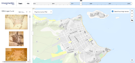
You can explore the evolution of Rio over the last half a millennium on the new digital atlas imagineRio. At the heart of this new digital atlas, developed at Rice University, is an interactive map which visualizes the changes in Rio's landscape and topography over time. Using the map's timeline control you can view a map of the city during any point in the last five centuries. As you move the timeline the interactive map automatically updates to display a map of the city as it looked at that point in its history.
imagineRio also allows you to search and view thousands of historical photos, architectural plans, vintage maps, and drawings & paintings of the city. These vintage maps, photos and paintings of Rio de Janerio are displayed in the map sidebar and can be filtered using the map's timeline control. You can also filter the images by location by clicking on the 'search as map moves' option.
imagineRio is just one of the recipients of a Getty Foundation's Digital Art History grant. Other digital mapping projects which have received grants and which are currently in development include a GIS web application exploring the archaeological excavations at the UNESCO World Heritage Site of Çatalhöyük in Turkey, a 3D map of Florence through time, and the Pompeii Artistic Landscape Project.


Comments