In August 1847 a railway line was opened connecting the Swiss cities of Baden and Zurich. 175 years later Switzerland's rail network is over 5,000 kilometers long. Swiss broadcaster SRF is celebrating 175 years of the country's railway network by taking you on a Journey Through the History of Swiss Railways.
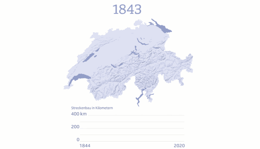
SRF's history of the Swiss railway includes a map which shows the opening of new railway lines by year of construction. This map is accompanied by a graph which shows the length (in km) of railway lines opened in each year. From the animation of this map above you can see that the golden era of the Swiss railway was in its first one hundred years. Since the 1920s further extensions to the railway in Switzerland have been fairly sporadic.
You can view animated maps of other rail networks being constructed around the world on the amazing Citylines.
Citylines is a collaborative platform which is busy mapping the public transit systems of the world. Using Citylines you can explore interactive maps visualizing the local transit systems of hundreds of cities around the globe. You can also use Citylines to explore how each city's public transport network has grown over time.
My favorite feature of Citylines is the ability to view a city's transit network developing through time. Each city's transit system map includes a date control, which allows you to view the extent of the local transit network for any year in history. Press the play button on the map and you can view an animated map showing how the city's transit system has developed through history.
All the data used on Citylines is open sourced under the Open Database License (ODbL). This means that if you want to create your own city public transit map then you can download the data for your map from Citylines (in json or CSV formats).

You can view a mapped visualization of the first 40 years of the London Underground network on my own
History of the London Underground. My animated map shows the development of the tube network from 1863-1900.
The London Underground began when the Metropolitan Line opened in 1863. This original line had seven stations and stretched between Paddington and Farringdon. By 1890 the network had grown to include a District Line and the beginnings of the Northern Line.
You can watch the London Underground grow during its first 40 years on my History of the London Underground map. If you press the 'Start' button on the map the London Underground lines will start to appear on the map in the order in which they were constructed. The animated tube lines were created using the
Leaflet.Polyline.SnakeAnim plugin for Leaflet.js.
If you want to reuse the code from my map then you are welcome to do so. You can clone my project on
Glitch.


Comments