Ukraine Under Attack
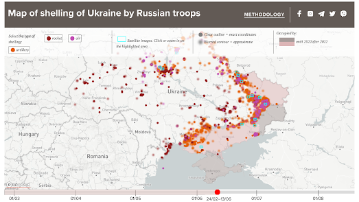
The Map of the Russian Shelling of Ukraine is a new interactive map which shows where and when Russia has bombed the people of Ukraine.
The map uses different colored markers to indicate the different types of shelling attacks (rocket, air or artillery). If you click on any of the markers you can view the date of the Russian attack and click-through to read any media reports about the selected shelling. The map includes a timeline feature which allows you to select to view attacks by date-range. You can adjust the end-date on this timeline to view the cumulative amount of shelling from the beginning of the Russian invasion until the selected date.
The Map of the Russian Shelling of Ukraine also features selected satellite images from Planet.com. If you zoom in on any of these satellite images you can see for yourself some of the damage caused by Russian missiles fired on Ukraine. At the moment the map is only available in Ukrainian. An option to view the map in English should be available from early next week.


Comments