Myriahedral Map Projections

In 2008 Jack van Wijk devised a new method for visualizing the Earth in two dimensions. His Myriahedral projections manage to map the Earth onto a flat surface with very little angular and area distortion.
Mapping a sphere onto a flat surface always requires some level of distortion. For example the Mercator projection has a large degree of area distortion and famously makes Europe and North America appear disproportionately large compared to Africa. Myriahedral projections attempt to reduce area and angle distortion as much as possible. In praising Jack van Wijk's Myriahedral projections CartoNerd's Kenneth Field says, "He managed to achieve a projection that reduces angular deformation to an absolute minimum and preserves area – not an easy trick."
You can explore a number of different Myriahedral Projections on Unfolding the Earth: Myriahedral Projections In WebGL. This interactive, WebGL powered, application allow you to view a number of different Myriahedral projections of the Earth using a number of different methods, including graticules, recursive subdivisions, platonic solids, archimedian solids and geography aligned meshes. For each map projection you can use the 'unfold' slider to see how the two dimensional map emerges from the spherical shape of the Earth.
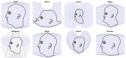
If you are interested in learning more about map projections then have a look at Projection Face. Projection Face is a great illustration of the distortions created by different map projections. The interactive shows how 64 different map projections effect our view of the world by showing each projection's effect when applied to something very familiar, the human face.
The distortions of each of the different projections can be illustrated further by clicking and dragging any of the mapped faces. This illustrates how the different map projections can be distorted themselves simply by changing the center of the map.
Projections Face is an interactive version of a 1924 illustration from Elements of Map Projection with Applications to Map and Chart Construction.
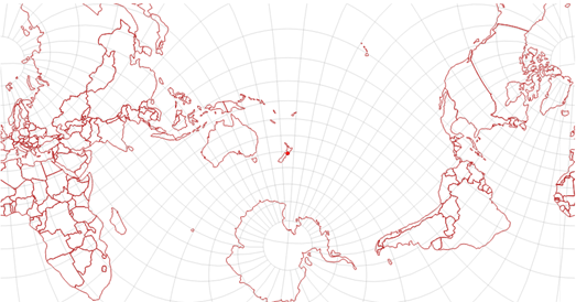
Degenerate State's Map Projections tool is another interesting visualization of how different map projections distort our picture of the world. Map Projections is a very similar tool to Projection Face but this interactive shows you how map projections effect maps of the Earth and not maps of a face.
The tool allows you to view a map of the world using 11 different map projections. This in itself is a good demonstration of the choices cartographers make when depicting a three dimensional sphere on a two dimensional plane. However Map Projections also allows you to explore how these different map projections would change if you changed the 0,0 point of latitude and longitude on the map. If you click anywhere in the world then the map will automatically change to show the distortion needed if this was the origin of the map.


Comments