Mapping the Internet of Things
Vista Data Vision - Real-Time Map
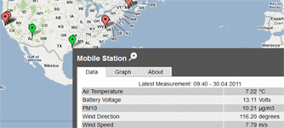
Vista Data Vision is an application to help you manage, visualise and analyse sensor data from real word objects. Using Vista Data Vision's applications it is possible to store logged data from devices and display and publish it to the web.
Vista Data Vision also provide an interface that allows users to view the data from logged devices via a Google Map. The demonstration map from VDV features mapped devices from weather stations and environmental sites around the world.
Using the map it is possible to view real-time data from a number of field measurement devices at different locations. The map displays the latest measurements and graphs of the data.
Pachube
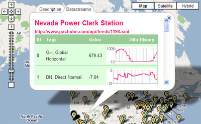
Pachube is a service that enables users to connect, tag and share real time sensor data from objects, devices, buildings and environments around the world. The key aim of the site is to facilitate interaction between remote environments, both physical and virtual.
The home page of Pachube features a large Google Map that displays live data feeds from a number of objects and devices around the world. The data feeds vary from weather stations, air quality sensors to domestic monitoring devices.
Tales of Things
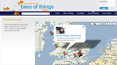
The Tales of Things allows you to tag real world objects. After being tagged the objects can then be geo-located on Google Maps and be followed on Twitter.
A free iPhone app allows anyone with an iPhone to scan, comment and add locations to objects. The application lets you take a photo and add a QR code to any object, that can then be followed on the Tale of Things.
If you find an object with a Tale's of Things QR code attached to it you can scan and decode the object on the Tale of Things website and learn more about its history and movements.
Tale of Things is a collaborative project from Brunel University, Edinburgh College of Art, University College London, University of Dundee and University of Salford.
________________
Vista Data Vision is an application to help you manage, visualise and analyse sensor data from real word objects. Using Vista Data Vision's applications it is possible to store logged data from devices and display and publish it to the web.
Vista Data Vision also provide an interface that allows users to view the data from logged devices via a Google Map. The demonstration map from VDV features mapped devices from weather stations and environmental sites around the world.
Using the map it is possible to view real-time data from a number of field measurement devices at different locations. The map displays the latest measurements and graphs of the data.
Pachube
Pachube is a service that enables users to connect, tag and share real time sensor data from objects, devices, buildings and environments around the world. The key aim of the site is to facilitate interaction between remote environments, both physical and virtual.
The home page of Pachube features a large Google Map that displays live data feeds from a number of objects and devices around the world. The data feeds vary from weather stations, air quality sensors to domestic monitoring devices.
Tales of Things
The Tales of Things allows you to tag real world objects. After being tagged the objects can then be geo-located on Google Maps and be followed on Twitter.
A free iPhone app allows anyone with an iPhone to scan, comment and add locations to objects. The application lets you take a photo and add a QR code to any object, that can then be followed on the Tale of Things.
If you find an object with a Tale's of Things QR code attached to it you can scan and decode the object on the Tale of Things website and learn more about its history and movements.
Tale of Things is a collaborative project from Brunel University, Edinburgh College of Art, University College London, University of Dundee and University of Salford.
________________


Comments