Mapping the Holocaust
Between 1941 and 1945 the Nazis murdered six million European Jews. This amounted to two-thirds of the Jewish population of Europe. The Jack, Joseph and Morton Mandel Center for Advanced Holocaust Studies has identified the locations of 1,096 ghettos created by the Germans in Nazi-occupied Europe. They have also identified the locations of 868 concentration camps.
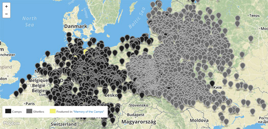
In Mapping the Holocaust PBS has mapped the 1,096 ghettos in Eastern Europe and the 868 concentration camps where Jewish people were murdered. The map represents just a small proportion of the number of Nazi ghettos and camps. The Jack, Joseph and Morton Mandel Center for Advanced Holocaust Studies believe that the true number of sites to be closer to 42,000.
The camps indicated by yellow markers on the map feature in the film Memory of the Camps. The documentary, Memory of the Camps, features some of the film that was captured at the camps when they were first liberated by the Allied forces towards the end of World War II.

Auschwitz concentration camp is just one of the 868 concentration camps featured on the Mapping the Holocaust map. Auschwitz was established by the Germans in occupied Poland in 1940. In the next few years it became the most deadly Nazi extermination camp. It is estimated that 1.1 million people perished in Auschwitz-Birkenau between 1940-1945.
The Auschwitz-Birkenau Memorial and Museum has 38,916 registration photographs taken of Auschwitz prisoners. They are working with Brazilian photo colorization specialist Marina Amaral and a team of academics, journalists and volunteers to colorize these photographs and to research and share the stories of those photographed.
You can explore these photos and the biographies of just some of the people killed by the Nazis on Faces of Auschwitz. The Faces of Auschwitz interactive map shows the home town locations of the individuals and stories completed so far. If you click on the map markers you can view the prisoner's colorized photograph and click through to read what is known about that individual's story.

The Vilnius Ghetto was a Jewish ghetto established and operated by Nazi Germany in the city of Vilnius, Lithuania. During the two years of its existence, starvation, disease, street executions, maltreatment and deportations to concentration camps and extermination camps reduced the population of the Vilnius Ghetto from an estimated 40,000 people to zero.
Exploring the Vilnius Ghetto: A Digital Monument is a Leaflet powered map that shows over two hundred points of historical significance, pulled from memoirs, archives, original Ghetto documents & artifacts, and oral and historical accounts. Users can explore the map on their own, using filters to find places and events of interest; or they can follow a number of curated stories.
Yahad – In Unum is an organization dedicated to identifying mass Jewish execution sites and mass graves in the countries of the former Soviet Union. The organization collects forensic evidence and seeks out eyewitnesses to the executions of Jews and Roma to identify holocaust sites where the Nazis and their allies murdered Jews in towns and villages throughout Eastern Europe.
The Map of Execution Sites is an interactive map of the sites that Yahad - In Unum has identified so far. The red markers on the map indicate the location of execution sites where Yahad - In Unum has added details of their investigations. If you select a red dot on the map you can read details about the site, including the number of witnesses interviewed and details and videos from eye witnesses to the site's use in the Holocaust.


Comments