Every Railway At Once

In January last year Andrei Kashcha released his very popular City Roads interactive map. City Roads is a fun online tool which can be used to create your very own road map for any city in the world. Enter a city name into City Roads and it will generate a map of the city using only the city's road network from OpenStreetMap.
One year later and we now have a rail version of City Roads. City Roads Railways is almost a direct clone of Andrei Kashcha's City Roads map, however where City Roads created a simple road map City Roads Railways can be used to create a simple railway map of your chosen city.
At the top of this post you can see a rail map of London which I made using the tool. Just enter a location into the map and you can make a similar simple rail map for any location on Earth.
The Arun Valley in the South Downs National Park, England
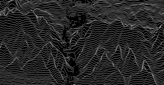
If you like playing with City Roads then you might also like Peak Map, which is from the same developer. Peak Map
is a fantastic interactive map which can create a joy-plot elevation map for any
location on Earth. To create your own joy-plot map you just need to
center Peak Map on your chosen location.
Joy-plots (or ridgeline plots as they are sometimes called) are inspired
by Joy Division's famous album cover for Unknown Pleasures. Peak Map
includes a number of options which allow you to change the appearance of
your generated joy-plot. The automatic setting draws black lines on a
white background but you can choose your own background and line colors
(my example above flips the default to show white lines on a black
background). You can also change the height scale and smoothness of the
elevation lines on your joy plot map and even reduce the joy plot map's
opacity to reveal a labelled map beneath.


Comments