The Top 10 Uses of Street View
Over the last few weeks I've been rather critical of the Google Maps API. However with Street View Google has an image layer that is simply not available with other mapping API's. I think it is therefore time to celebrate the wonderful websites that developers have created with Google Maps Street View.
Here then are the top ten uses of Google Maps Street View:
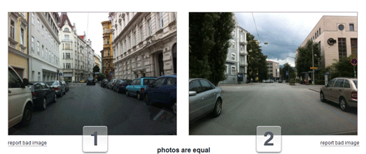
1. GeoGuessr

The number one spot is claimed by GeoGuessr. GeoGuessr has proved to be the one of the most popular applications ever built with the Google Maps API. It therefore rightly belongs at the top of our list of the greatest ever uses of Street View
GeoGuessr is a Street View geography quiz that sets you the challenge of guessing the locations of a series of random Street View images. Using visual clues, such as the fauna, landscape and street furniture you have to place a pin on a global Google Map indicating where you think each Street View image was taken.
The closer your guess to the actual location then the more points you win.
2. Street View Hyperlapse

If there is one application that could challenge Geoguessr as the most popular Street View app it would be Hyperlapse.
There have been a few apps over the years that allow you to create animated drives using a series of Street View images. Street View Hyperlapse is the smoothest one yet.
Street View Hyperlapse uses Hyperlapse.js, Three.js, GSVPano.js, and the Google Maps API to create really smooth animated Street View movies. Users of Street View Hyperlapse can search for any location with Google Street View coverage. All you then need to do is drop two map markers for the start and end of your drive and then press 'create'.
The result is an amazing animated drive through a series of Street View images.
3. Hashima Island - The Forgotten World

Hashima Island is probably my personal favorite application built with Google Maps Street View.
The abandoned Japanese island of Hashima, in Nagasaki Prefecture is an eerie ghost town that was captured on Street View in 2013. Hashima Island - The Forgotten World is an amazing tour of Google's Street View imagery of the island, which includes the historical background of the featured locations and the desolate landscape.
The site is a great guide to the island, adding context and the back-story to Google's amazing imagery of the island. The Street Views in this tour have been enhanced with some CSS3 filters to create an even spookier atmosphere which is intensified further by the accompaniment of some suitably spectral background music and sound. The children's voices and school bells that play when you stand in Hashima Primary School playground made the hairs on the back of my neck stand-up.
4. Historypin

Over the years Street View has proved very popular with lovers of vintage photographs. It is always fascinating to be able to compare historical views with the current view shown on Google Maps Street View.
Historypin is the most accomplished of the many websites that have emerged that allow you to view vintage photographs superimposed on Street View.
5. Perfect Storms

Another popular use of Street View over the years has been to provide a personal touch to product promotions. These applications tend to use the Street Views of users' own homes with some added special effects. The History Channel's Perfect Storms is one of the best examples of the use of Street View in a promotion campaign.
To promote the last season of Perfect Storms the History Channel created this interactive that allows you to virtually destroy your house in a fire storm. The app uses a combination of Google Maps and Street View to show the likely effects of a perfect storm on your own home and neighborhood.
6. Place Pulse
Street View has also been put to more serious use. MIT used Street View to carry out a survey measuring respondents' perceptions of locations based on how they look on Google Maps Street View.
MIT's Place Pulse project is a crowd-sourced experiment examining people's perceptions of different urban environments. The project aims to quantitatively recognize which areas of a city are perceived as wealthy, modern, safe, lively, active, unique, central, adaptable or family friendly based on how people respond to Street View images of the city.
The Place Pulse Rankings page looks at the results of the survey, which consist of 100,000 images from 56 cities. The rankings table shows the results for each evaluated perception for each of the 56 cities. Users can therefore see which cities are perceived as the most wealthy, safe, lively etc and also view all the rankings for each of the cities.
7. Nature Valley Trail View

The Google Maps API also provides the option for developers to create Street View tours using their own personal panoramic imagery. The best use of custom Street View has been by the Nature Valley Trail View.
Nature Valley Trail view provides beautiful Street View tours of the Grand Canyon, Yellowstone Park, the Great Smokies and Sequoia.
8. Floating Shiny Knot

Floating Shiny Knot is an impressive experiment that superimposes animation on top of Google Maps Street View. The application superimposes an animated shiny knot on top of any Street View image (you can choose a chrome or glass finish for the knot).

#rorschmap was one of my favorite Google Maps apps of 2011. The map lets you zoom in on any location on Earth and, using the same principle of multiple reflection that you find in kaleidoscopes, create an animated Rorschach satellite view.
The #rorschmap - Street View edition applies the same technique to Google Maps Street View. Just enter your address into the app and you can drop-down the rabbit-hole and create your own kaleidoscope home!
10. There and Then

There and Then is a collection of historic vintage movies superimposed on top of the same view as seen today in Google Maps Street View. This app lets you travel back in time and view some of the earliest recorded film, while at the same time allowing you to view the scene as it looks today.
If you like these Street View applications then you might also like 5 Fun Ways to Destroy Your House on Street View
.
Here then are the top ten uses of Google Maps Street View:
1. GeoGuessr
The number one spot is claimed by GeoGuessr. GeoGuessr has proved to be the one of the most popular applications ever built with the Google Maps API. It therefore rightly belongs at the top of our list of the greatest ever uses of Street View
GeoGuessr is a Street View geography quiz that sets you the challenge of guessing the locations of a series of random Street View images. Using visual clues, such as the fauna, landscape and street furniture you have to place a pin on a global Google Map indicating where you think each Street View image was taken.
The closer your guess to the actual location then the more points you win.
2. Street View Hyperlapse
If there is one application that could challenge Geoguessr as the most popular Street View app it would be Hyperlapse.
There have been a few apps over the years that allow you to create animated drives using a series of Street View images. Street View Hyperlapse is the smoothest one yet.
Street View Hyperlapse uses Hyperlapse.js, Three.js, GSVPano.js, and the Google Maps API to create really smooth animated Street View movies. Users of Street View Hyperlapse can search for any location with Google Street View coverage. All you then need to do is drop two map markers for the start and end of your drive and then press 'create'.
The result is an amazing animated drive through a series of Street View images.
3. Hashima Island - The Forgotten World
Hashima Island is probably my personal favorite application built with Google Maps Street View.
The abandoned Japanese island of Hashima, in Nagasaki Prefecture is an eerie ghost town that was captured on Street View in 2013. Hashima Island - The Forgotten World is an amazing tour of Google's Street View imagery of the island, which includes the historical background of the featured locations and the desolate landscape.
The site is a great guide to the island, adding context and the back-story to Google's amazing imagery of the island. The Street Views in this tour have been enhanced with some CSS3 filters to create an even spookier atmosphere which is intensified further by the accompaniment of some suitably spectral background music and sound. The children's voices and school bells that play when you stand in Hashima Primary School playground made the hairs on the back of my neck stand-up.
4. Historypin
Over the years Street View has proved very popular with lovers of vintage photographs. It is always fascinating to be able to compare historical views with the current view shown on Google Maps Street View.
Historypin is the most accomplished of the many websites that have emerged that allow you to view vintage photographs superimposed on Street View.
5. Perfect Storms
Another popular use of Street View over the years has been to provide a personal touch to product promotions. These applications tend to use the Street Views of users' own homes with some added special effects. The History Channel's Perfect Storms is one of the best examples of the use of Street View in a promotion campaign.
To promote the last season of Perfect Storms the History Channel created this interactive that allows you to virtually destroy your house in a fire storm. The app uses a combination of Google Maps and Street View to show the likely effects of a perfect storm on your own home and neighborhood.
6. Place Pulse
Street View has also been put to more serious use. MIT used Street View to carry out a survey measuring respondents' perceptions of locations based on how they look on Google Maps Street View.
MIT's Place Pulse project is a crowd-sourced experiment examining people's perceptions of different urban environments. The project aims to quantitatively recognize which areas of a city are perceived as wealthy, modern, safe, lively, active, unique, central, adaptable or family friendly based on how people respond to Street View images of the city.
The Place Pulse Rankings page looks at the results of the survey, which consist of 100,000 images from 56 cities. The rankings table shows the results for each evaluated perception for each of the 56 cities. Users can therefore see which cities are perceived as the most wealthy, safe, lively etc and also view all the rankings for each of the cities.
7. Nature Valley Trail View
The Google Maps API also provides the option for developers to create Street View tours using their own personal panoramic imagery. The best use of custom Street View has been by the Nature Valley Trail View.
Nature Valley Trail view provides beautiful Street View tours of the Grand Canyon, Yellowstone Park, the Great Smokies and Sequoia.
8. Floating Shiny Knot
Floating Shiny Knot is an impressive experiment that superimposes animation on top of Google Maps Street View. The application superimposes an animated shiny knot on top of any Street View image (you can choose a chrome or glass finish for the knot).
The
effect is very impressive and if you rotate and drag the Street View
around then the application soars to even higher levels of
impressiveness.
#rorschmap was one of my favorite Google Maps apps of 2011. The map lets you zoom in on any location on Earth and, using the same principle of multiple reflection that you find in kaleidoscopes, create an animated Rorschach satellite view.
The #rorschmap - Street View edition applies the same technique to Google Maps Street View. Just enter your address into the app and you can drop-down the rabbit-hole and create your own kaleidoscope home!
10. There and Then
There and Then is a collection of historic vintage movies superimposed on top of the same view as seen today in Google Maps Street View. This app lets you travel back in time and view some of the earliest recorded film, while at the same time allowing you to view the scene as it looks today.
If you like these Street View applications then you might also like 5 Fun Ways to Destroy Your House on Street View


Comments