

The Distressed Communities Index ranks the economic well-being of every community in the United States. It uses seven different metrics to assess the economic state of every zip-code area. The 2017 DCI Map allows you to view the well-being score of every zip-code in the United States and to view each of the individual economic metrics for each area.
The seven metrics which are used to determine the Distress Score are:
- No High School Diploma
- Housing Vacancy Rate
- Adults Not Working
- Poverty Rate
- Median Income
- Change in Employment
- Change in Businesses

The level of family debt is not one of the metrics used in the Distressed Communities Index but it could also be used as an indicator of the economic well-being of different communities. The Urban Institute's Debt in America visualizes debt levels in every county in the USA. The map allows you to view the median debt levels in a county and compare them to debt levels for the state and the country as a whole. The map also allows you to view the average household income in every state.
Using the map sidebar you can select from a number of debt metrics, including the share and value of medical debt in each county. If you then click on a county on the map you can view the debt totals for the county in the map sidebar. The debt totals for the county, the state and for the whole country are also shown beneath the map.
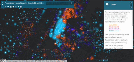
Esri's Predominant Income Range by Households map shows how much money people are earning in each census tract in the United States. The map uses income data from the 5-year American Community Survey in 2016 to show the income range of the most people in each tract. Using the map you can explore the reality of income inequality in every local neighborhood.
While exploring the map you might spot patterns which recur in states, cities and communities across the country. For example you should be able to spot the income divide between many metro and rural areas. In college towns you might see low income student-dominated neighborhoods surrounded by wealthier neighborhoods.
The map reveals that a number of cities, such as Philadelphia, Seattle and Houston have a thriving downtown core. While cities such as Detroit and Cleveland have urban centers which are struggling or dying.

Food Insecurity in the United States is an interactive map which shows the number of people who need food assistance in each county in the United States. The map uses data from Feeding America’s annual Map the Meal Gap project.
There are a number of clusters of counties, especially in the south east, which have high levels of food insecurity. Many of these, for example in the Mississippi Delta, are in areas where agriculture and food production are the biggest industries.
If you select a state on the map you can view a detailed overview of food insecurity in the state. You can also click on individual counties to discover the food insecurity rate and the number of food insecure people in the selected county.
No comments:
Post a Comment