The Rising Risks of Wildfire

Global heating has doubled the area of Europe which has a very high risk of wildfire. Civio has mapped the Copernicus Climate Change Service's meteorological forest fire risk index for every year since 1971. The map shows that The territory of Europe at high risk of fires has doubled in the last 50 years.
Europeans living in the Canary Isles, Greece, Sicily and the Algarve - which all experienced devastating wildfires this year - will need no reminding of the effect that climate change is having on the chances of life-threatening wildfires. Civio's animated map of 'days per year with very high or higher fire risk in Europe' shows that large areas of southern Europe now experience much higher risks of severe wildfire than they did 50 years ago.If you click on an area on the map and select a year you can view how many days in the year had a risk of wildfire (broken down into very extreme risk, extreme and high). Beneath the map you can also view the percentage of the country chosen which was affected by fire risk in that year (again this is broken down to show the percentage of days at very extreme risk, extreme and high risk).
So far.
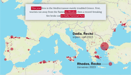
Czech news website Aktuálně.cz has analyzed satellite data of European Union wildfires since the year 2000 to calculate the total burnt area caused by fires for every year this century. A storymap in Burnt Europe maps out the size of European wildfires in 2024, 2023 and 2017 (the year with the highest total burn area). An interactive map at the end of the story also allows readers to explore in detail the wildfire burnt areas for every year since 2000.
A bar chart and line graph visualize the number of hectares burnt in each of the last 23 years. The data used for the charts and maps was taken from the satellite imagery of the European Forest Fire Information System. The Aktuálně.cz article includes a number of satellite images taken from EFFIS documenting some of Europe's worst wildfires this century.


Comments