It's Like Google Earth For Real
Britain from Above (dead link removed)
The BBC have produced a Google Map to accompany a television programme called Britain from Above that starts tomorrow night in the UK.
For the television series the BBC have employed plane, helicopter, microlight, parachutes, satellite technology and innovations in aerial photography to present the UK as seen from the air. British newspaper The Telegraph have described the programme as "like Google Earth, but for real".
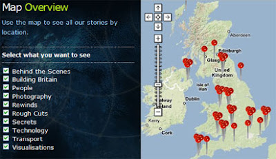
The map itself has a number of tags divided into categories, 'Behind the Scenes', 'Building Britain', 'People', 'Photography', 'Rewinds', 'Rough Cuts', 'Secrets', 'Technology', 'Transport' and 'Visualisations'. Each of the tags contain links to photographs and video clips from the television series.
Google and the BBC now need to release the imagery produced for the series as a layer in Google Earth.
The series starts 10th Aug 2008 21:00 (BST) on BBC 1.
Via: Mapperz
_________________
The BBC have produced a Google Map to accompany a television programme called Britain from Above that starts tomorrow night in the UK.
For the television series the BBC have employed plane, helicopter, microlight, parachutes, satellite technology and innovations in aerial photography to present the UK as seen from the air. British newspaper The Telegraph have described the programme as "like Google Earth, but for real".
The map itself has a number of tags divided into categories, 'Behind the Scenes', 'Building Britain', 'People', 'Photography', 'Rewinds', 'Rough Cuts', 'Secrets', 'Technology', 'Transport' and 'Visualisations'. Each of the tags contain links to photographs and video clips from the television series.
Google and the BBC now need to release the imagery produced for the series as a layer in Google Earth.
The series starts 10th Aug 2008 21:00 (BST) on BBC 1.
Via: Mapperz
_________________


Comments