Real-Time Ship Tracking on Google Maps
The International Maritime Organization (IMO) requires all vessels over 299GT to carry an AIS transponder on board. The transponder transmits data on position, speed and course, among some other static information, such as the vessel’s name, dimensions and voyage details.
Thanks to this AIS data there are now a lot of Google Maps mashups showing the real-time positions of ships around the world.
Here are a few ship tracking maps:
MarineTraffic.com
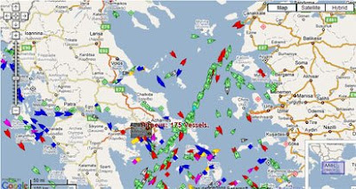
MarineTraffic.com have produced a Google Map showing real-time information about ship movements throughout the world.
NOAA Fleet Map
Google Map tracking the ships of the National Oceanic and Atmospheric Administration.
Entrance of the Loire Estuary

Live ship tracking in the Loire Estuary, France. Includes a nautical map overlay.
Hat-tip: Magic Instinct
_____________
Thanks to this AIS data there are now a lot of Google Maps mashups showing the real-time positions of ships around the world.
Here are a few ship tracking maps:
MarineTraffic.com
MarineTraffic.com have produced a Google Map showing real-time information about ship movements throughout the world.
NOAA Fleet Map
Google Map tracking the ships of the National Oceanic and Atmospheric Administration.
Entrance of the Loire Estuary
Live ship tracking in the Loire Estuary, France. Includes a nautical map overlay.
- Live AIS for Boca Raton, Florida
- Portland, Oregon
- San Francisco Bay
- Seattle Live Ship Tracker
- Pointe à Pitre, Guadeloupe
- Live AIS Ship Tracking - Norway
- Live AIS data for Kristiansand
- Live AIS Stockholm
- Northern Baltic (Also Stockholm)
- Bay of Botnia, Sweden/Finland
- Saltdean (English Channel) Live Ship tracking
- Cape Pine Newfoundland
Hat-tip: Magic Instinct
_____________


Comments
Not a very sophisticated UI, but I must admit they were on of the first on the web to offer this service).
http://www.ship-hunters.be/AIS/Overview.htm
Thank you google :)