The Age of Agglomerations
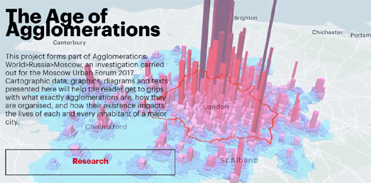
The Age of Agglomerations is a new study and data visualization exploring some of the major urban agglomerations around the world. The research and visualization was completed by Urbica for the Moscow Urban Forum 2017.
The data visualization tool at the heart of the Age of Agglomerations allows you to explore demographic, commuting and other data about the featured cities displayed on interactive maps. The Age of Agglomerations includes a comparison tool which allows you to view the same data for two different cities side by side on two different maps.
You can read more about the definition of agglomerations, how the boundaries were determined for the selected cities and how you can use the tools to explore the interactive maps on this Urbica blog post. The interactive maps have been created using Mapbox and make liberal use of Mapbox GL's extrude property for the 3d data visualizations.
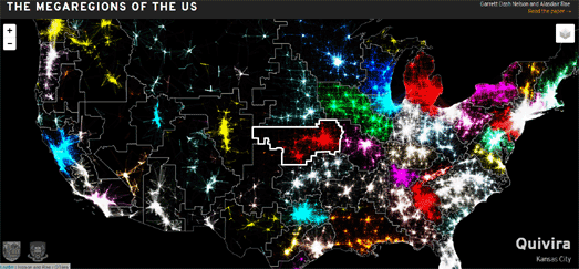
The outer zones of the agglomerations in the Age of Agglomerations were determined by areas where at least 15% of the population commute to work into the inner zone of the agglomeration. Garrett Dash Nelson and Alasdair Rae also used 'commuting zones' to help identify 50 regions of the United States based on distinct separate labor markets. Their identified megaregions of the United States were determined by analyzing over 4,000,000 commuter journeys.
You can view the results of Nelson & Rae's analysis of commuter journeys in the USA on the Megaregions of the United States interactive map. The map shows the borders of the identified megaregions. It also shows the commuter journeys which determined the shape of each of these new megaregions. If you hover over any of the megaregions on the map you can view the name that Nelson & Rae has given the megaregion and the name of the major city at the center of its distinct interconnected labor market.
The map is powered by the Leaflet.js mapping library. The data itself was made into slippy map tiles by using QTiles, a QGIS plugin for creating raster map tiles for interactive maps.


Comments