
Warning: You are going to be hooked!
Ifitweremyhome.com

Recently there has been a spate of Google Maps that allow you to compare the size of the Gulf oil spill with places you know. Ifitweremyhome.com and Paul Rademacher's How Big is the Gulf of Mexico Oil Spill? both allowed you to place an overlay of the oil spill over a location you know well. The ability to compare the spill to a place that you know really helps to convey the sheer size of the Gulf oil disaster.
Ifitweremyhome.com also has a great country comparison tool that allows you to compare the size of different countries by placing an overlay in the shape of one country over another. Users can compare the size of any country with any other country and can even view a number of economic and lifestyle comparisons of the two compared countries.
So, for example, in the screenshot above the shape of the UK is laid on top of the USA. The map is accompanied with some interesting facts that tell you that,
"If the United Kingdom were your home instead of the United States you would make 24.14% less money and live 0.92 years longer but that you would experience 24.44% less of a class divide, consume 55.61% less oil, have a 22.15% lesser chance of dying in infancy and have a 13.98% better chance at being employed."
BBC Dimensions
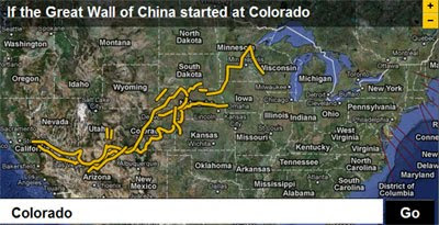
This prototype website for the BBC is taking the map based comparison idea a whole lot further. Dimensions takes a larger number of important places, events and things, and overlays them onto a Google Map of where you are.
It is hard to know where to begin with this site as there are just so many comparisons that you can make. The screenshot above shows the Great Wall of China, only as if it was in the USA. Alternatively you could compare the moon to your home state or you could view the Twin Towers footprint placed over your house or see how much of your neighborhood would be overrun if Burning Man was held in your garden.
There are so many comparisons that you can view on Dimensions that you should be prepared to lose a substantial part of your day to this website. I can guarantee that Dimensions is going to have you hooked.
Oxfam: Pakistan Floods

Whilst we are on the subject of comparison maps the charity Oxfam are using a screenshot of the Pakistan floods overlaid on a Google Map of the UK to help convey the scale of this emerging disaster.
Oxfam are using the image as part of a campaign to encourage Europeans to email the president of the European Commission to ask him to do more to help those affected. The image shows that if the flood were in Europe it would stretch from Aberdeen in Scotland to Paris.
_____________
1 comment:
I checked all three maps and they're great! Aside from being informative, they also serve a noble purpose of prompting people into action (Europe can and give more to Pakistan.) They all deserve to be Google maps of the month. :)
Post a Comment