What a Relief
Mundialis is a beautiful new interactive topographical map of the world.
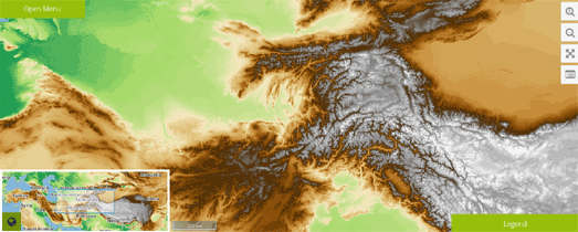
The map uses SRTM DEM 450m elevation data, and bathymetry sea & lake data (from Natural Earth & NGDC respectively). The map also includes the option to view an OpenStreetMap road map layer on top of the topographical map or on its own as the base map.
Currently the map includes a small inset map showing the global position of the current map view. It also includes a map layers menu, which allows you to select the topography map, a grey scale topography layer, topography with OSM or OpenStreetMap on its own. As yet the map does not offer a search feature.
You can read more about the data sources for Mundialis, how the raw data was styled and information about the Web Map Service for the Mundialis web client in this Making of: Topography Layer with OSM Overlay article.


Comments