Annual Weather Patterns
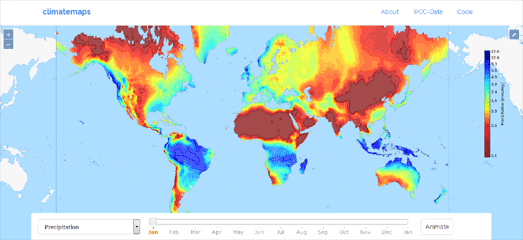
Climatemaps visualizes the weather over the course of a year around the whole world. The map animates average global monthly climate data from 1961-1990 to show you when every location in the world has its hottest, driest or wettest weather.
You can select from a range of weather layers from the drop-down menu (including precipitation, cloud cover and average temperatures). You can then view the weather data animated on the map through a whole year (you might need to let the animation play through a couple of times before the layers load completely).
The map was made with the OpenLayers 3 map library with a little help from Tippecanoe to create the map tiles. Tippecanoe is a tool for building vector map tilesets containing large amounts of location data. It is a very efficient way to visualize very large data-sets on an interactive map with minimal impact on performance.
You can view a few over maps built with the help of Tippecanoe here.


Comments