Maps of the Week

The Urban Fabric Map is a great new interactive map tool which allows you to compare side-by-side the building footprints of different cities around the world. Comparing the building footprints of cities in this way can reveal interesting differences in the street layouts and building densities of different cities across the globe.
The Urban Fabric Map uses OpenStreetMap building data. This map data is displayed using a custom created Mapbox style.
In the screenshot above I have compared San Francisco with London. The comparison reveals the clear grid like pattern of San Francisco's streets compared to London's more organic street layout. A building count is also displayed above each of the two maps. This reveals that San Francisco has around three times as many buildings in the same sized area as London. This is despite the fact that the Golden Gate Park is a prominent feature on the San Francisco map.

If you've ever dreamed of becoming a property tycoon then you might want to practice your real-estate skills on Next.Land. Next.Land is a multiplayer city building game built on top of an interactive map of the real world. The object of the game is to buy buildings, upgrade your properties and earn a fortune from your rental returns. The full game is scheduled for release in early 2007.
However you can get a sneak preview of the game on the Next.Land Demo map. In the demo game you can explore 30 real-world locations on the interactive map and become familiar with the basic game-play features. The maps are built on OpenStreetMap and SRTM data. Each of the locations feature 3d buildings which you can purchase (if you have enough money). Unfortunately in this demo of the game you can't save your progress.
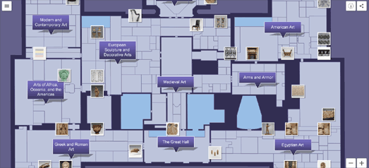
The Met Navigator is a wonderful indoor map of the Metropolitan Museum of Art in New York. It provides an independent floor-plan of the Met's Fifth Avenue museum..
One reason that the Met Navigator works so well is that the level of detail shown on the map is dependent on the zoom level. The more you zoom in on map the more detail is shown on the floor-plan. If you zoom in completely on a gallery you can even view pictures and details on each of the individual exhibits.
The map was created with the Meurs Navigator library. There is nothing here, however, that you couldn't easily achieve using any of the other popular mapping platforms.


Comments