Citizen Mapping for the Environment
A new crowd-sourced tool plans to monitor deforestation and other environmental damage caused to the planet around the world. Map for Environment uses OpenStreetMap mapping tools with satellite imagery of known logging, industrial agriculture, dam, and fracking locations to help map how these industries are effecting the environment.
Most importantly - You Can Help! If you log-in to Map for Environment with an OpenStreetMap account you can begin to help map logging roads, the spread of industrial agriculture, dams and fracking sites.
Each of these four industrial activities have their own separate citizen mapping project. For example, if you log-in to the Logging Roads project, you can begin mapping to help monitor the spread of logging roads in the Congo Basin. You will be shown a series of historical satellite imagery of the same location. Logging roads are identified on the satellite imagery. All you need to do is identify the date when the logging road first appears on the satellite imagery.
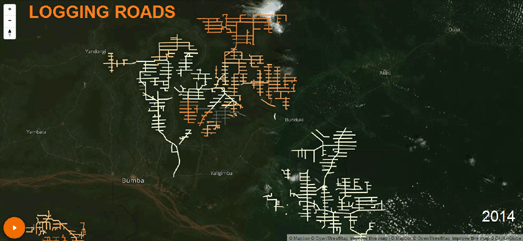
You can observe the huge spread of logging roads in the Congo Basin on an animated Logging Roads map. This map uses historical satellite imagery to show the spread of logging roads in the Congo Basin over recent years. By contributing to the Logging Roads project you will help to make this map more accurate.


Comments