OSM World
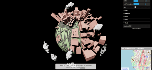
Little Big City is a fun WebGL experiment which creates a small world based on OpenStreetMap data. Pan the inset map on Little Big City and you can view a little city made big on a small 3D globe.
The globe visualizes buildings, roads and water from OpenStreetMap on top of a small 3D globe. A radius control allows you to change the scale of the map data shown on the map. Increase the radius and you can view a slightly bigger small 3D globe.
The map itself is initially zoomed in on Manhattan. Unfortunately the map doesn't include zoom controls or a search facility. This makes it a little difficult to pan the map to a new location. For example, I assume it would take about 15 minutes for me to pan across the Atlantic to view my neighborhood in London
Little Big City reminds me a little of Ecolapse, which creates a similar 'small world' effect using Google Maps Street View imagery.
Ecolapse is a nice extension of the Hyperlapse library created by Teehan+Lax (Hyperlapse itself unfortunately seems to no longer exist - although the source code for Hyperlapse is still available on Github). Using Ecolapse you can create an animated Street View drive with a very clever overhead 'small world' effect. Ecolapse distorts the Google Street View imagery to portray an overhead view rather than the normal Google Maps landscape view.
You can create your own animated Ecolapse tour simply by dropping two map markers onto a Google Map. When the animation is created you have the option to pause the animation, zoom in and out of the Street View and use your keyboard arrow keys to scroll through the route frame by frame.


Comments