Plastic Polluted River & Oceans

Around 8 million tonnes of plastic is dumped into the world's oceans every single year. Plastic which is dangerous to marine life and, once it enters the food chain, dangerous to the health of people as well. This plastic comes from homes across the world. Mismanaged plastic waste and waste which is intentionally dumped enters the world's rivers and then flows into our seas. Studies are now beginning to map where this plastic ends up and where it originates from.
Litterbase is one organization attempting to collate the results of scientific studies researching the levels of plastic pollution found in the world's oceans. Currently Litterbase provides a summarized overview of the results from over 1,900 studies into the amount and composition of litter and its effect on marine environments. An example of one of these summaries is Distribution of Litter Types in Different Realms, which is an interactive map created from the results of 916 scientific publications on the amount, distribution and composition of litter in the world's oceans.
The map shows the results of hundreds of scientific studies carried out in specific locations around the world. It is not a heatmap of marine pollution around the world. It only shows the levels of pollution in the areas where studies were carried out. The markers on the map do show the levels of plastic and other types of pollution detected at different locations across the globe. However there are gaps in seas and oceans where little scientific research has taken place, for example around Africa and the Polar regions.
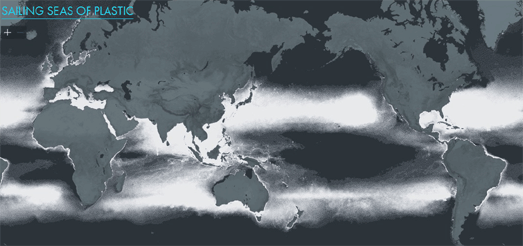
One way that we can fill in these gaps in our knowledge is by modeling the density of pollution in the oceans based on the results of scientific studies. Sailing Seas of Plastic is a dot density map which shows the estimated concentration of floating plastic in the oceans based on the results of 24 survey expeditions (2007-2013) and on wind and ocean drift models.
Each dot on the Sailing Seas of Plastic map represents 20 kg of floating plastic. According to the map there are 5,250 billion pieces of plastic adrift on the seas of the world. If you want you can also overlay the sailing tracks of the 24 survey expeditions on top of the dot map.

The Seas of Plastic is another visualization of the floating plastic debris that is polluting the world's oceans which is based on ocean drift models. The visualization includes an interactive globe showing the five large circulating gyres of plastic in the North Pacific, North Atlantic, Indian, South Atlantic and North Atlantic oceans.
The data for the Seas of Plastic visualization comes from a Lagrangian particle tracking model which simulated 30 years of input, transport and accumulation of floating plastic debris around the world. The model tracks the paths of plastic particles from land to sea and estimates the relative size of each of the five circulatory gyres.
The visualization also includes a Sankey Diagram that shows the amount of plastic debris which different countries contribute to each of these five circulating gyres. This diagram reveals that China is by far the biggest polluter of the world's oceans, followed closely by Europe. The notion that China is the source for a large proportion of ocean pollution is supported by the Ocean Cleanup campaign.

The Ocean Cleanup organisation believes that between 1.15 and 2.41 million metric tons of the plastic in the oceans originates from the world's river systems. Two thirds of it from the rivers of Asia. To help explain how and where plastic ends up in the world's oceans the Ocean Cleanup has released an interactive map, River Plastic Emissions to the World’s Oceans.
This map shows river systems around the globe. The predicted input from each river system is shown at the coast using scaled circular markers. These predicted inputs are based on a model which looks at population density, waste management, topography, hydrography, the locations of dams and the reported concentration of plastic in rivers around the world.
You can learn more about how the plastic you place in your trash ends up in the world's oceans in a National Geographic story map. In What Happens to the Plastic we Throw Out National Geographic explains how domestic plastic trash ends up polluting a remote island in the middle of the South Pacific. As you progress through National Geographic's story a background map of the South Pacific shows the levels of mismanaged municipal plastic waste produced by countries on the Pacific Ocean. Much of this plastic waste eventually ends up in the Pacific. Carry on scrolling and the map updates to show the levels of plastic waste entering the ocean from rivers in Asia and North, Central & South America.
National Geographic identifies the Yangtze River as the most polluted river in the world. Most of the pollution from the Yangtze eventually ends up in the Pacific by way of the East China Sea. The background map animates the modeled pathways of marine debris to show how the plastic from the world's rivers ends up creating the huge plastic gyres which are polluting our oceans.


Comments