Road Orientations and Street Directions

Last year Geoff Boeing's Comparing City Street Orientations proved to be a very popular visualization of the street patterns in 25 major American cities. Using a series of compass roses Geoff revealed that the majority of U.S. cities adhere to a fairly strict grid system of roads. He then compared the strict grid system of many U.S. cities to the more organic street patterns found in other cities around the world.
His City Street Orientations around the World visualization includes similar compass rose charts showing the street orientations of 25 cities across the globe. When you look at the street orientations of American cities side-by-side with some of the much older global cities you can see how older cities tend not to have the same strict grid cities of younger cities in the USA.
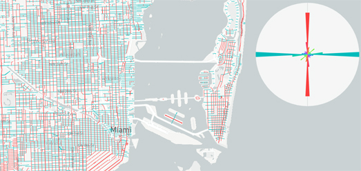
In many American cities the street grid system is often reflected in the names of the city's streets. For example in some cities you might find that all roads called 'Avenue' run north to south, while all roads called 'Street' run west to east (or vice versa depending on the city). It is possible to visualize this pattern very effectively with an interactive map and a radial chart. My Miami Streets map visualizes the directions of all roads called 'avenue' and 'street' in Miami.
On the map all roads named 'Avenue' are colored red and all roads named 'Street' are colored blue. Simply by looking at the map you can tell that streets and avenues run in distinctly different directions in Miami. The radial chart on top of the map visualizes this more explicitly, showing the overall orientation of all the streets and avenues in the current map view (move the map around and the radial chart will update to show the orientation of all streets and avenues in the current map view).
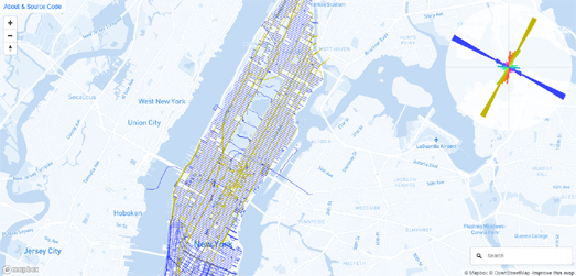
New York has a similar grid system to Miami. However in Manhattan the direction of the street grid system follows the directions of the Hudson and East Rivers, so in Manhattan streets and avenues are offset a little from the true cardinal directions. My New York Street Orientations map visualizes the directions of all roads called 'avenue' and 'street' in Manhattan. On this map all roads named 'Avenue' are colored gold and all roads named 'Street' are colored blue.

In both New York and Miami 'Avenues' run north-south and 'Streets' run west-east. This isn't true in every US city. You can see that in a new visualization by Data Stuff. Data Stuff's Street Network Orientation by Road Type visualizes the street orientations of many different road suffixes (including Avenues and Streets) in 25 U.S. cities. The visualization shows you the orientations of not only Streets and Avenues but also Drives, Boulevards, Roads, Terraces, Places, Courts and Ways.
You can see in this visualization how Streets and Avenues seem to be the two road suffixes which are most used in city grid systems. They tend to be the two types of road suffix which are used in the major roads in these grid systems. However Streets and Avenues don't follow the same directions in every city. As we saw earlier - in Manhattan and Miami 'Avenues' run north-south. Data Stuff's visualization shows us that in Atlanta, Cleveland, Denver and Las Vegas Avenues run west-east and in these cities 'Streets' run in the north-south direction.


Comments