AI Time Travel
One of my favorite interactive maps of all time is Geneve 1850. In the nineteenth century Swiss architect Auguste Magnin created an amazing 3D model of the walled city of Geneva. This physical 3D model is usually on display at the Maison Tavel in Geneva. However an interactive online map of the model was also created - called Geneve 1850 (I'm not sure if the map still works as it requires Flash and I no longer have a browser which supports Flash).
There is something truly special about being able to walk around a 3D map of a city as it looked in the past. I spent hours wandering around 19th Century Geneva on Geneve 1850.
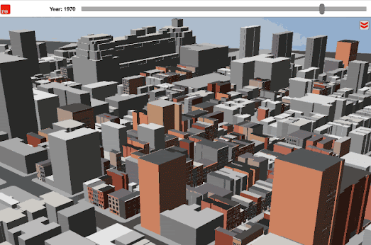
Now, thanks to Google, it is possible to build your own historical 3D map for any town or city in the world. Google has launched a browser-based mapping platform, called rǝ, which can recreate 3D maps of towns and cities as they would have appeared in the past. The platform uses historical vintage maps and vintage photographs to reconstruct towns and cities as they would have appeared at a particular time in their history. By creating a series of 3D maps of a city at different periods during its development rǝ can show how cities have changed over time.

a screenshot of the incredible Geneve 1850
The rǝ interactive map currently allows you to explore 3D maps of U.S. towns and cities over time. Using the map timeline you can select to view the historical map of a city for any year since 1800. Click on the '3D' button and you can walk around the city, as it looked in the past, in glorious 3D.
Google has open-sourced the tools which have been used to create rǝ. Which means if your town or city is not already on rǝ then you can create your own 3D historical map instead. Google Research's Kartta Labs tools allow you to take vintage maps of a location and to reconstruct a 3D map of the location from this original historical map.
Essentially Karrta Labs uses Map Warper to allow you to geo-rectify a vintage, historical map. It then allows you to trace over the geo-rectified vintage map to create a digital map of the original. This traced data is then turned into a vector map, which can then be displayed using the Kartta interactive map platform. Allowing you to walk around your vintage map in three dimensions.


Comments